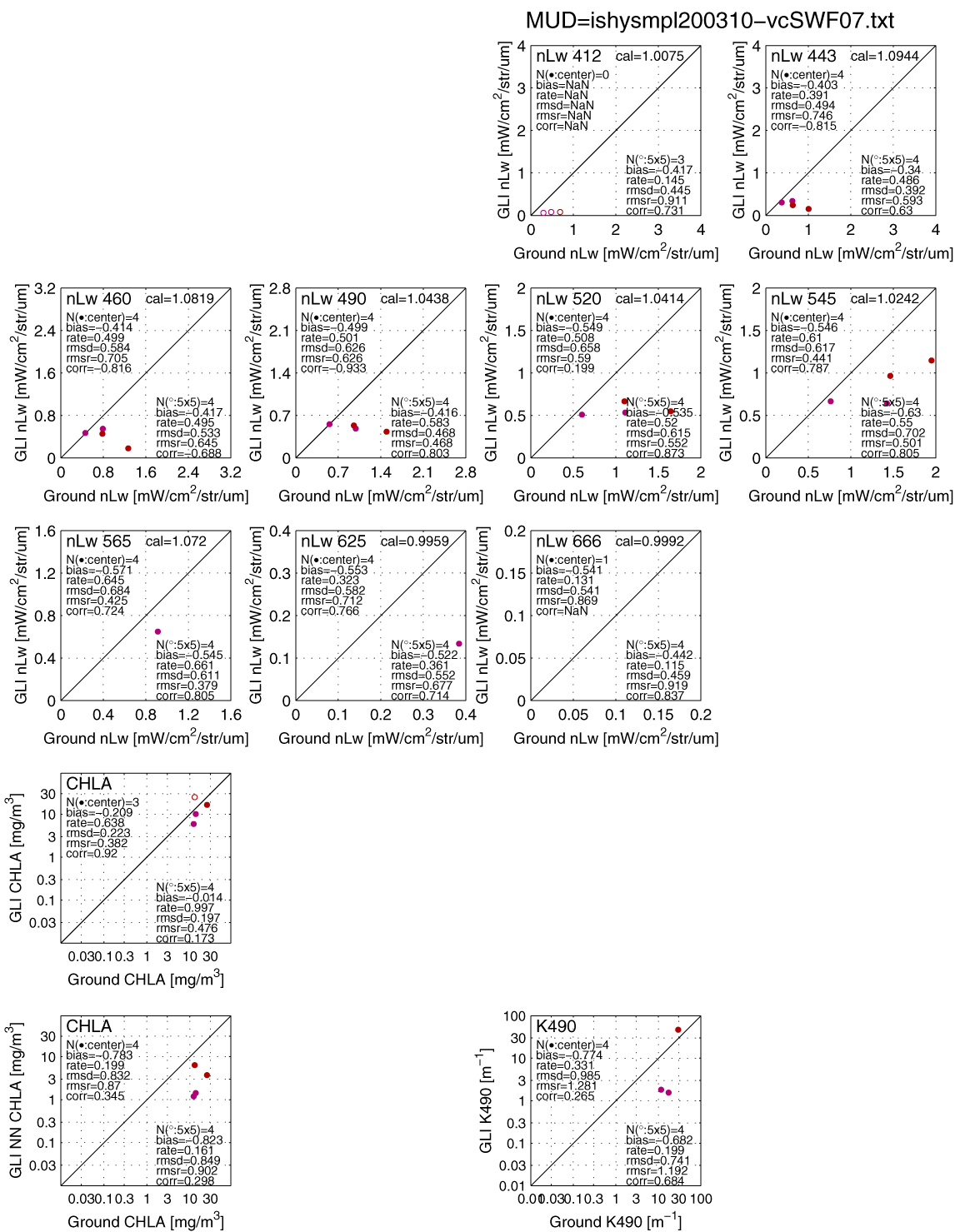
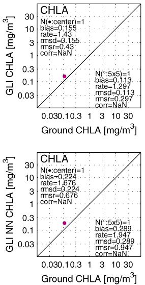
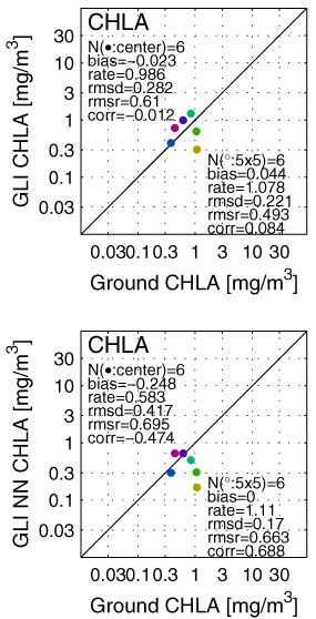
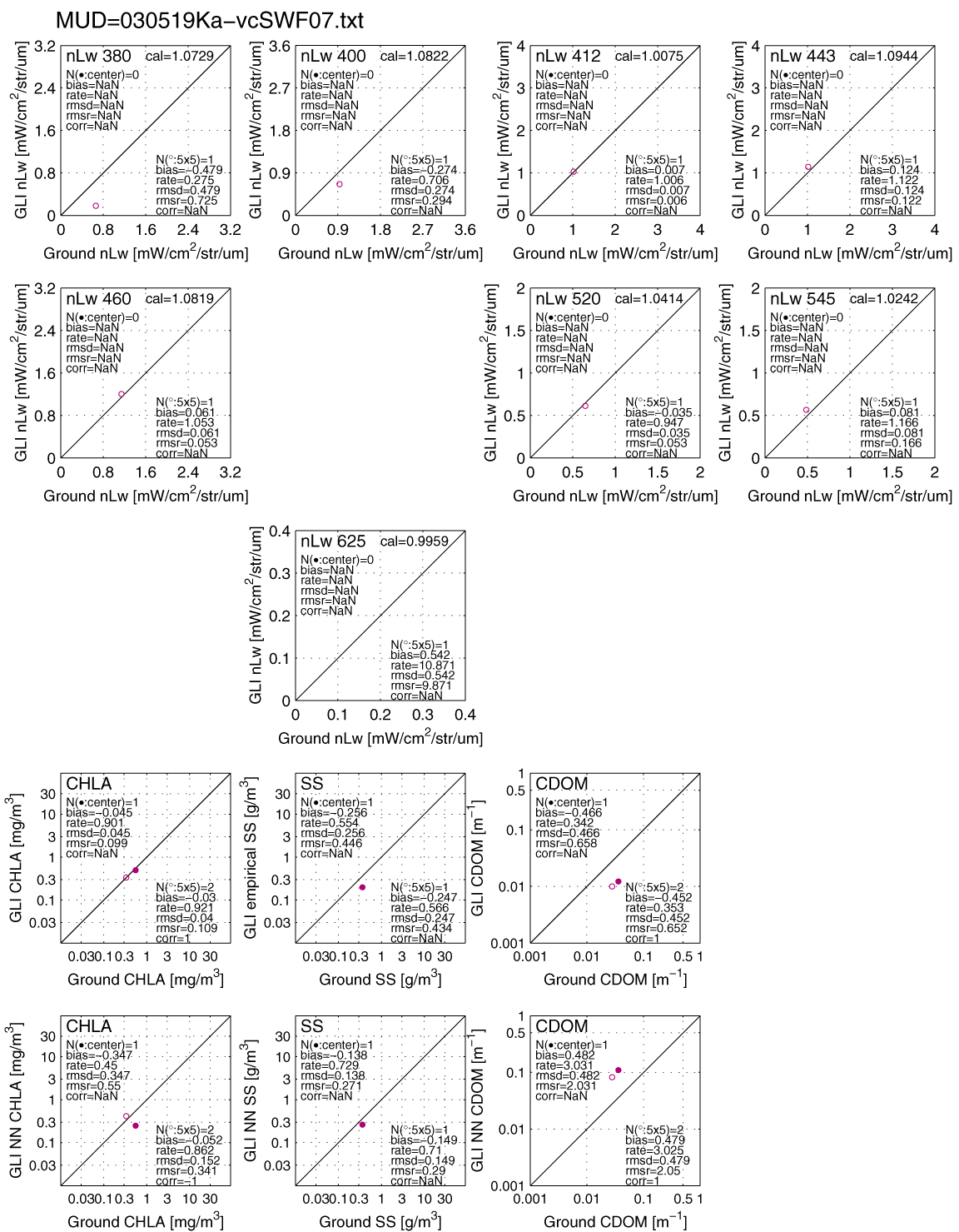
 ALL nLw and
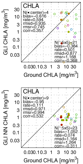
CHLA (Ver.1 / Ver.2,
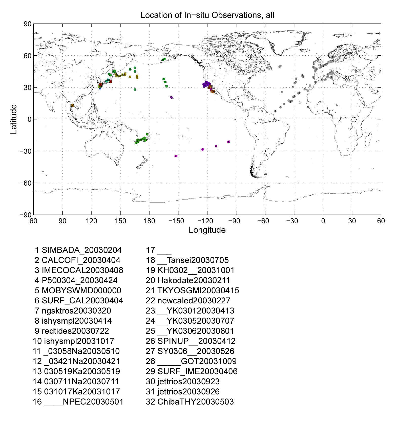
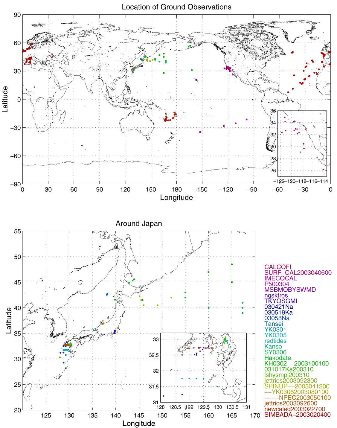
ID:1~27) and Locations of the ground
observations
ALL nLw and
CHLA (Ver.1 / Ver.2,
ID:1~27) and Locations of the ground
observations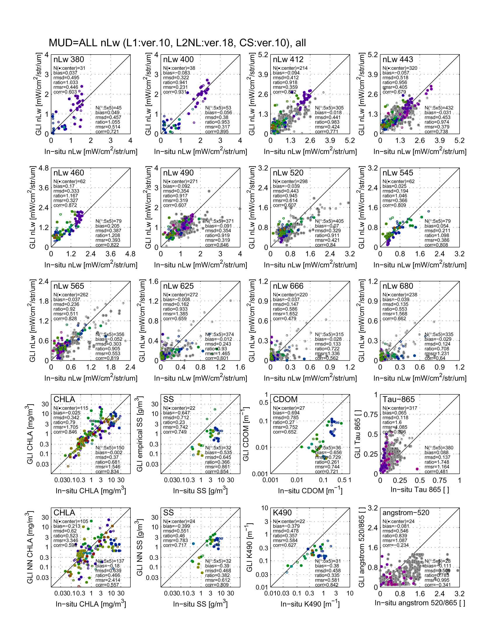

GLI Level-2 Ocean color match-up
analysis
last updated on 13 Dec. 2004
ALL nLw and
CHLA (Ver.1 / Ver.2,
ID:1~27) and Locations of the ground
observations
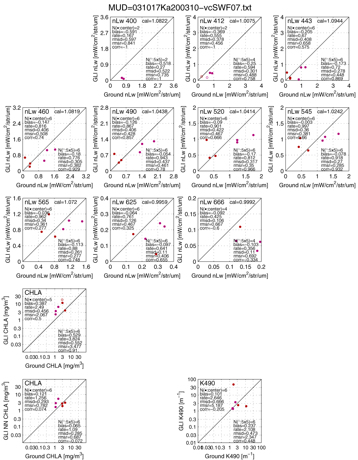
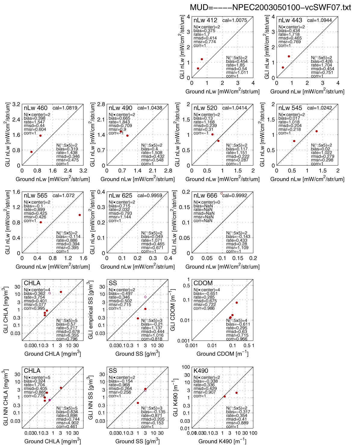
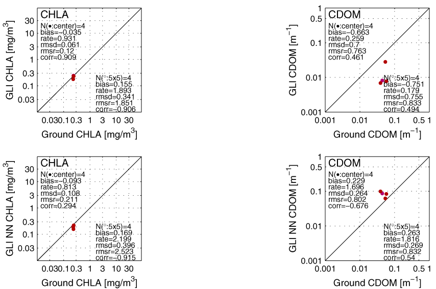
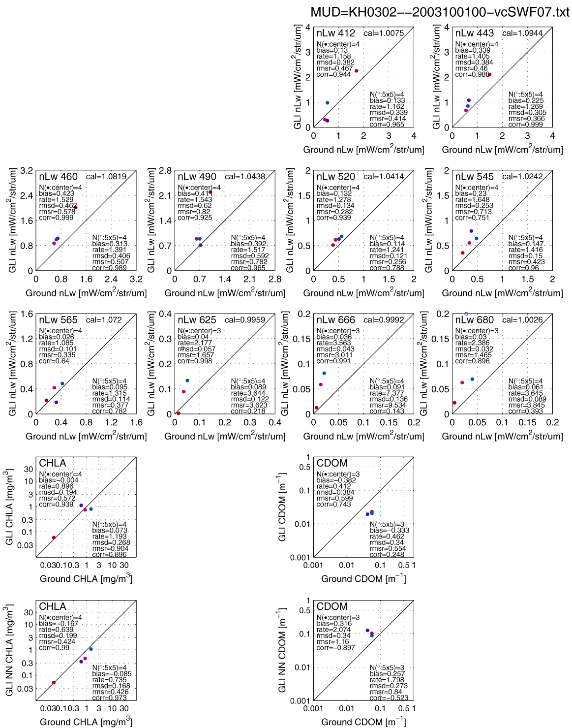
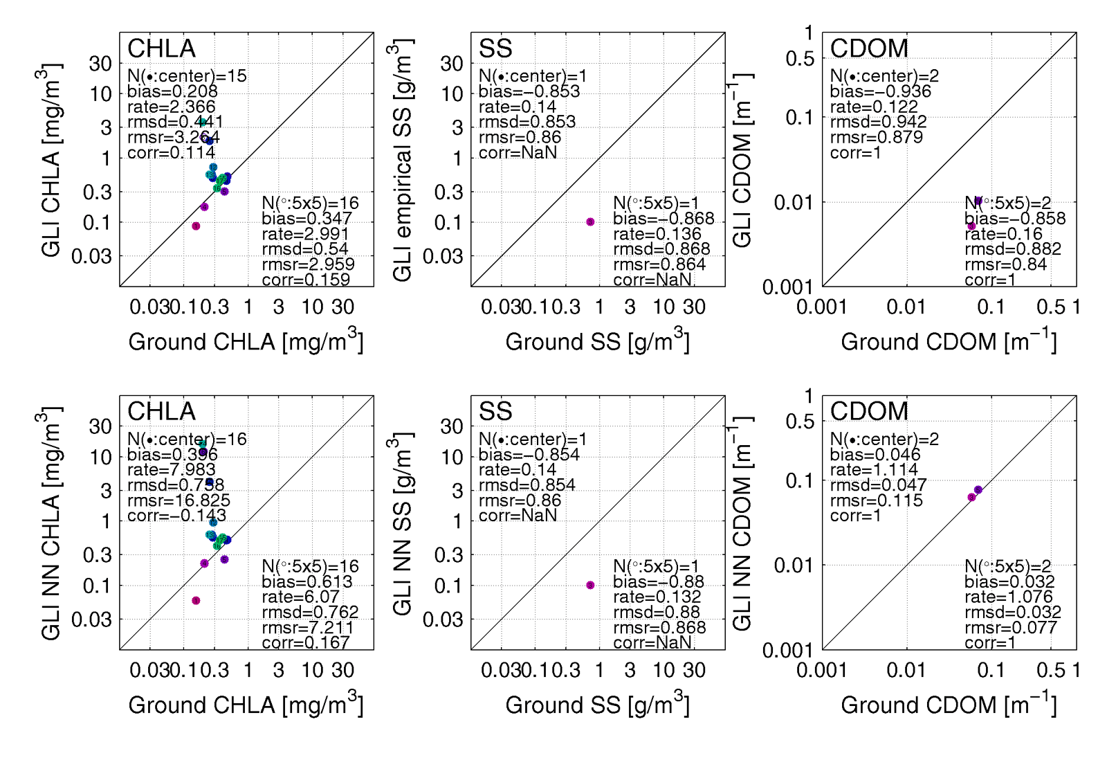
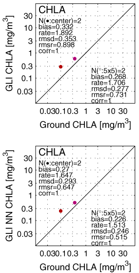
All (3-26) in one PDF file (Ver.2)
All scatters, All
locations, and each SIMBADA scatters, locations
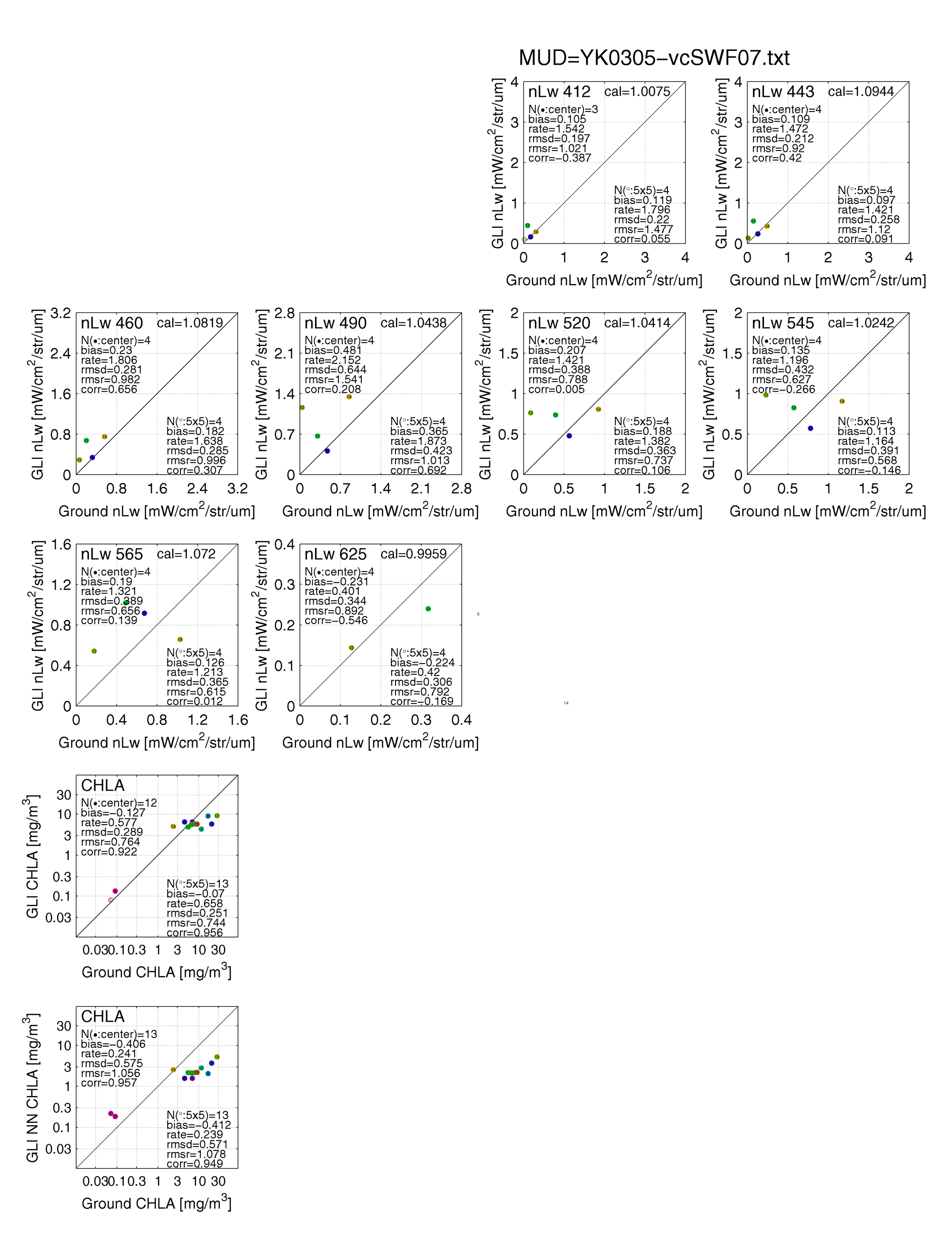
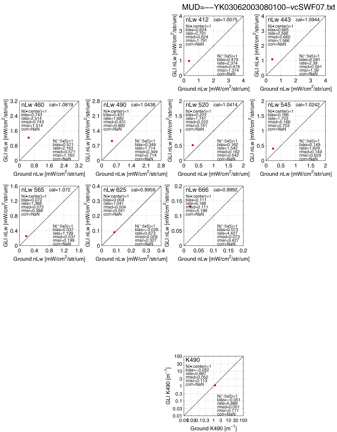
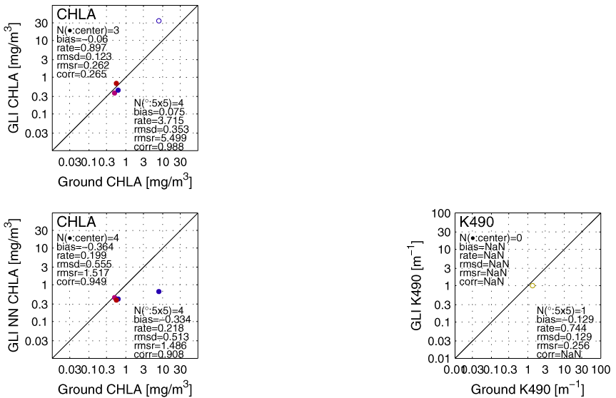
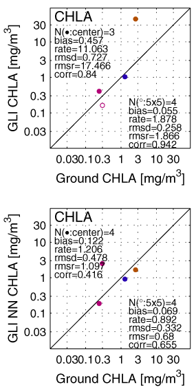
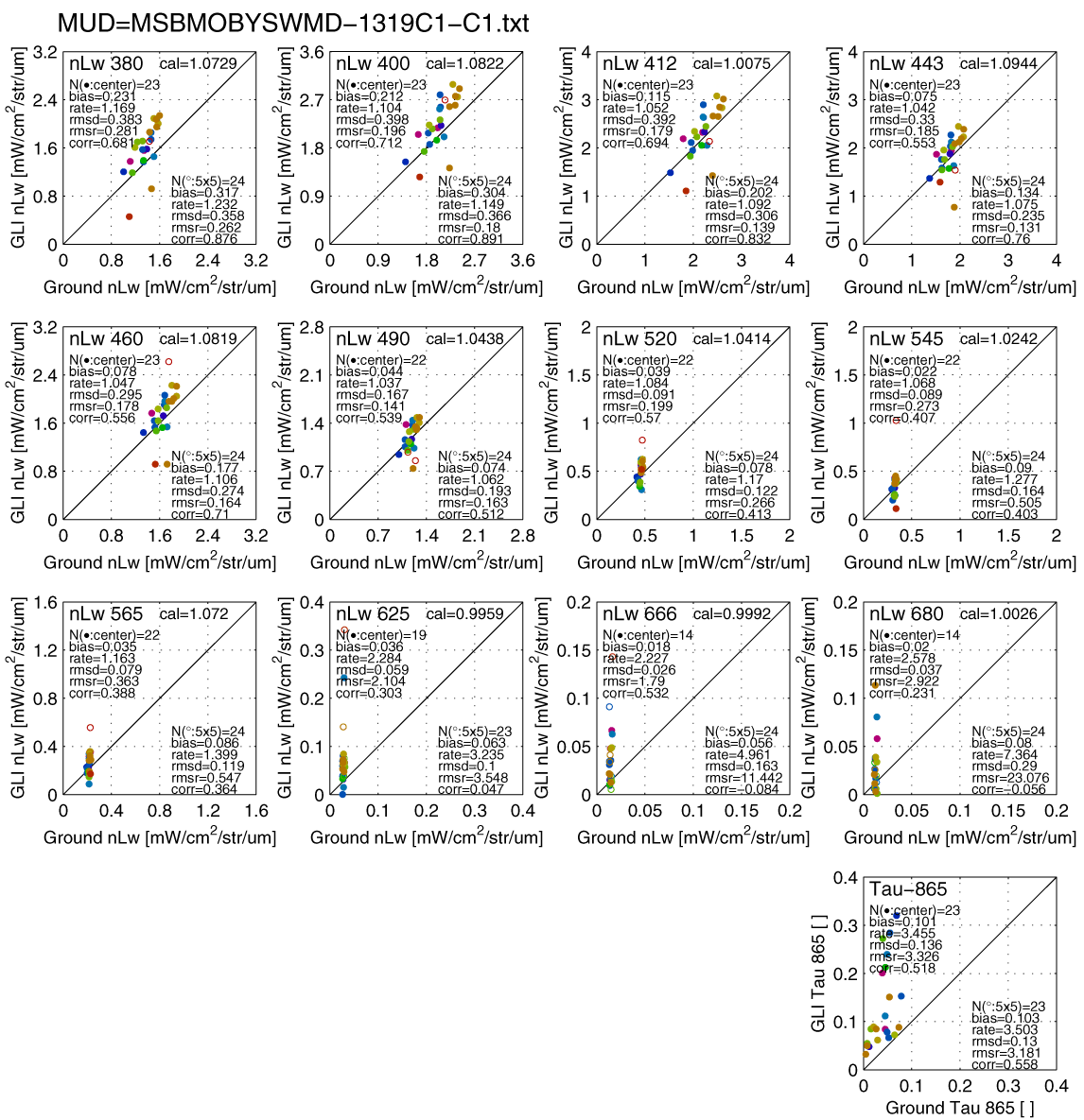
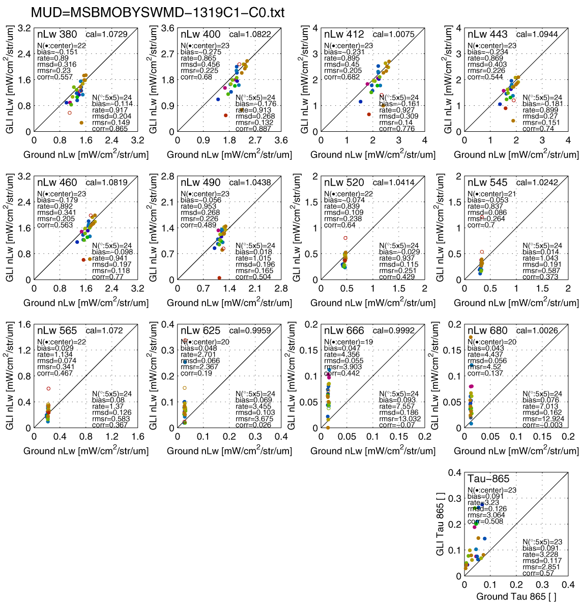
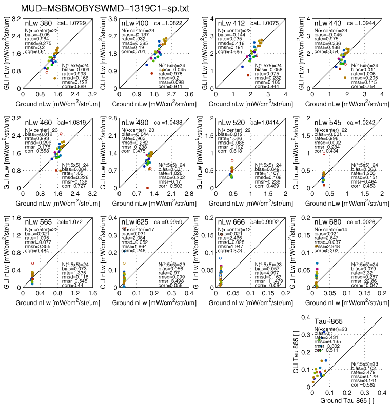
List of Match-up scatter
diagrams (updated on 13 Dec 2004)
|
|
Observation |
period |
nLw |
chla |
ss |
cdom |
k490 |
tau |
V1 |
V2 |
Observer/ Provider |
P |
|
- |
Total*2 |
month |
25-110 |
84 |
17 |
22 |
21 |
31 |
o |
o |
GLI PI and collaborators |
- |
|
1 |
Univ. Lille SIMBAD-A |
2-10 |
287(SIMBAD-A) |
|
|
|
|
281 |
o |
o |
nLw collected by P-Y Deschamps, and provided by R. Frouin HP |
2.1 |
|
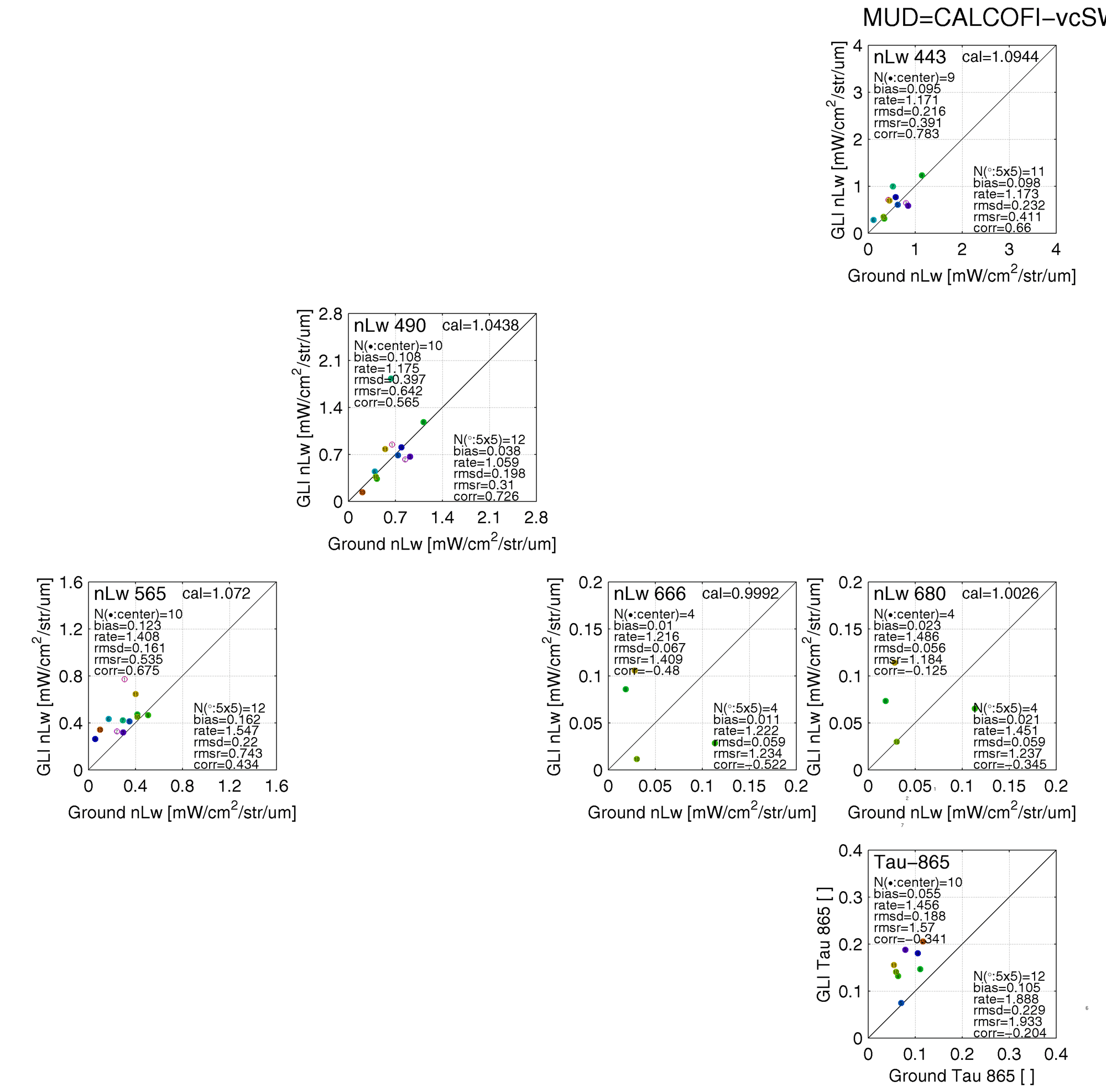
2 |
CALCOFI |
4 |
3-10 |
|
|
|
|
11 |
o |
R. Frouin, SIO HP |
2 | |
|
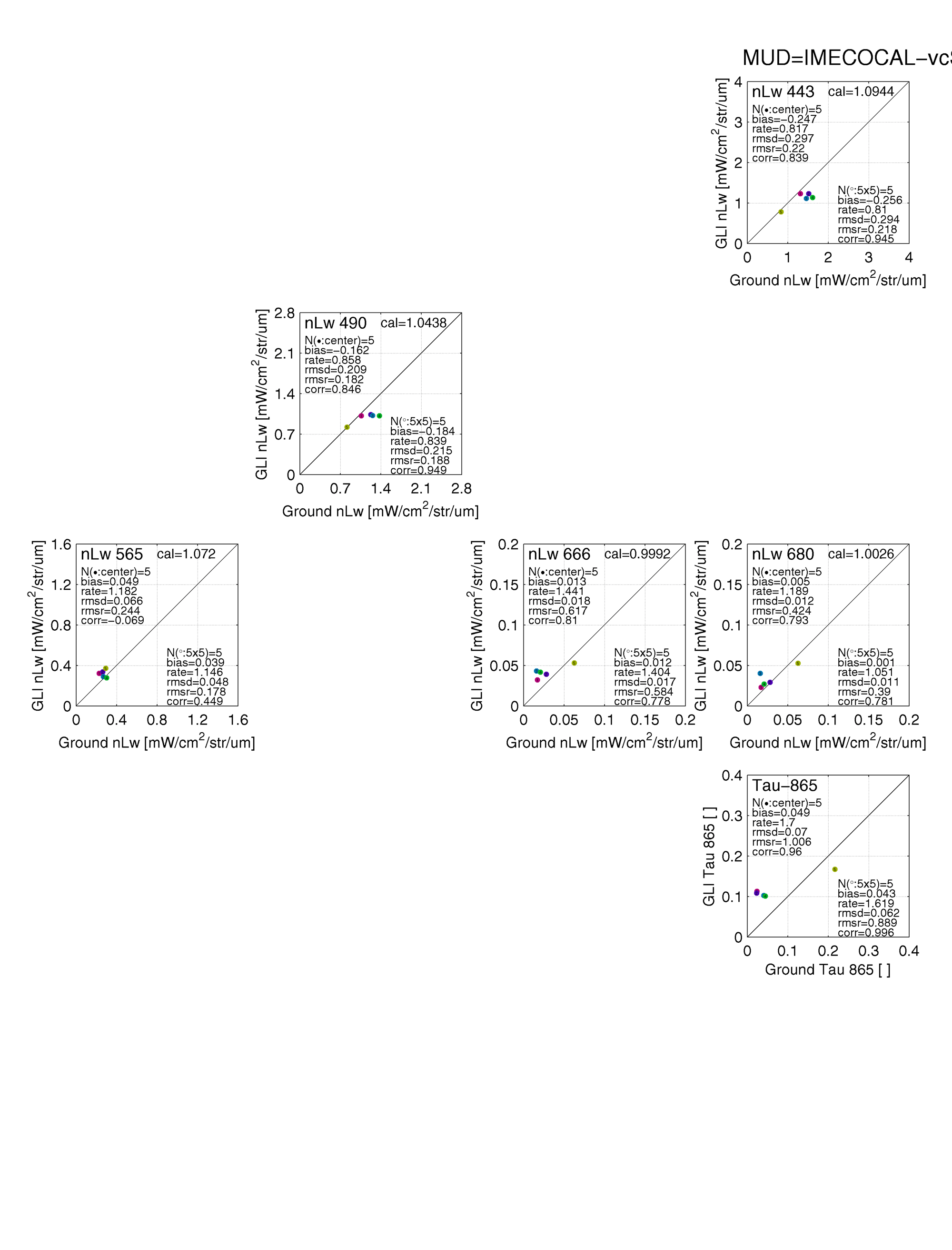
3 |
IMECOCAL |
4 |
7-10(SIMBAD) |
|
|
|
|
10 |
o |
R. Frouin, SIO |
2 | |
|
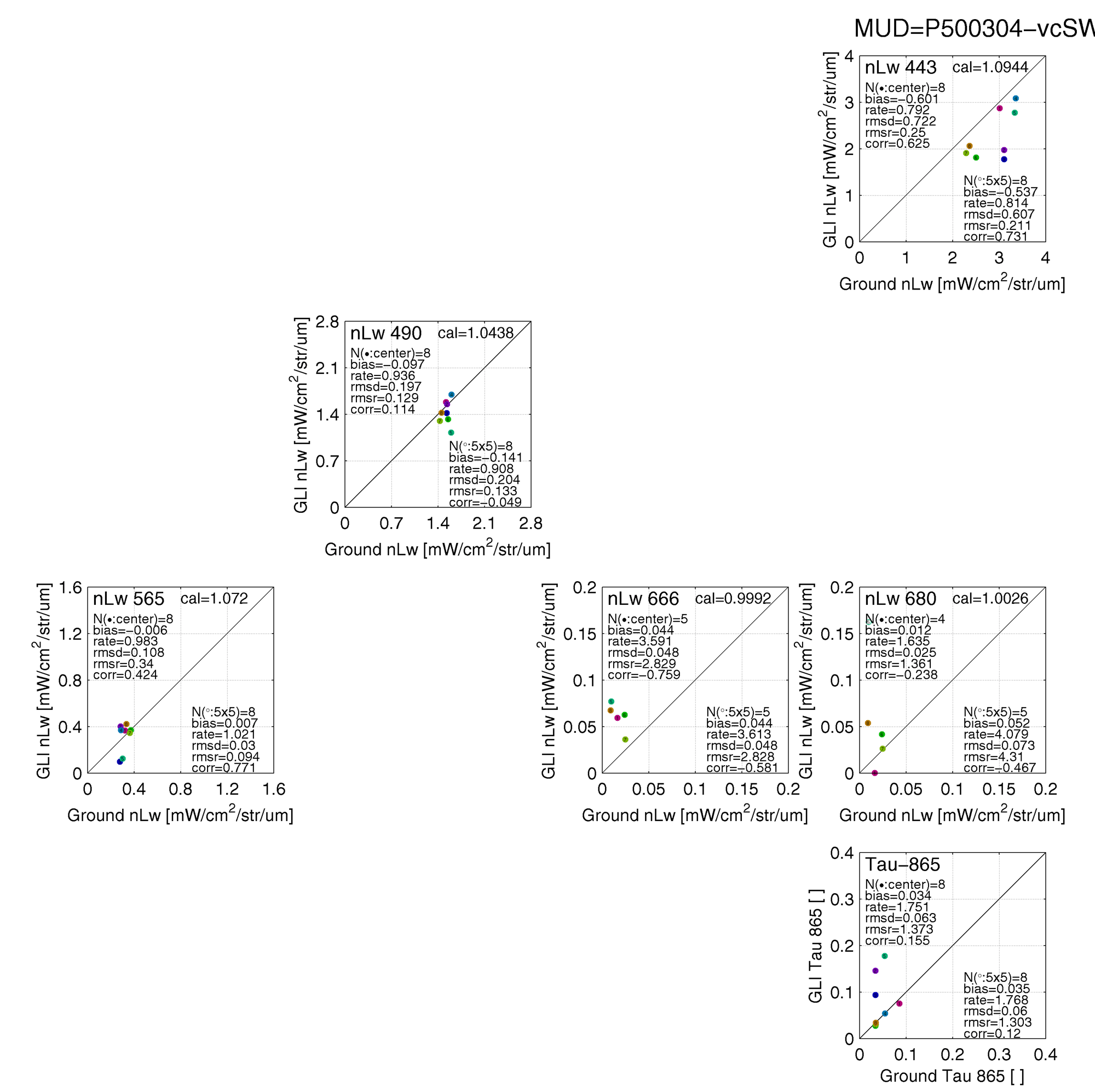
4 |
P500304 |
4 |
3-6 |
|
|
|
|
7 |
o |
D. Cutchin, SIO |
2 | |
|
5 |
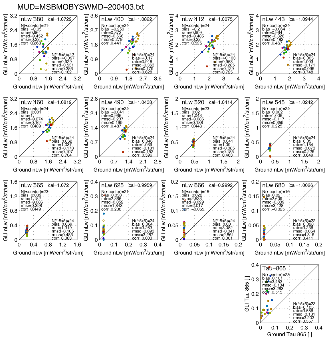
MOBY*1 |
2-10 |
18-21 |
|
|
|
|
22 |
o |
MOBY nLw by D. K. Clark, NOAA,
|
2 | |
|
6 |
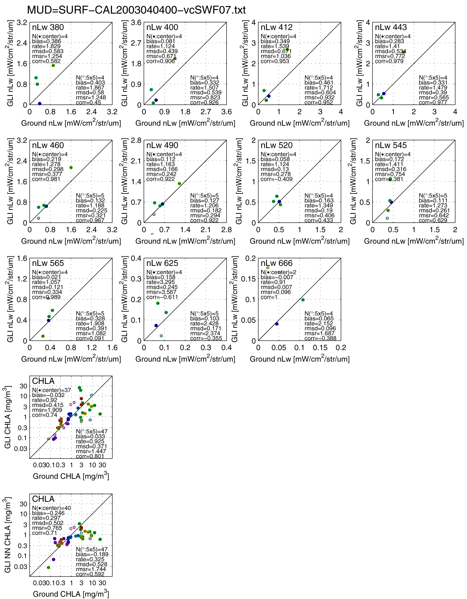
SURF_CAL |
4 |
2-6 (PRR800) |
39 |
|
3 |
|
|
o |
o |
B. G. Mitchell, SIO HP |
3 |
|
7 |
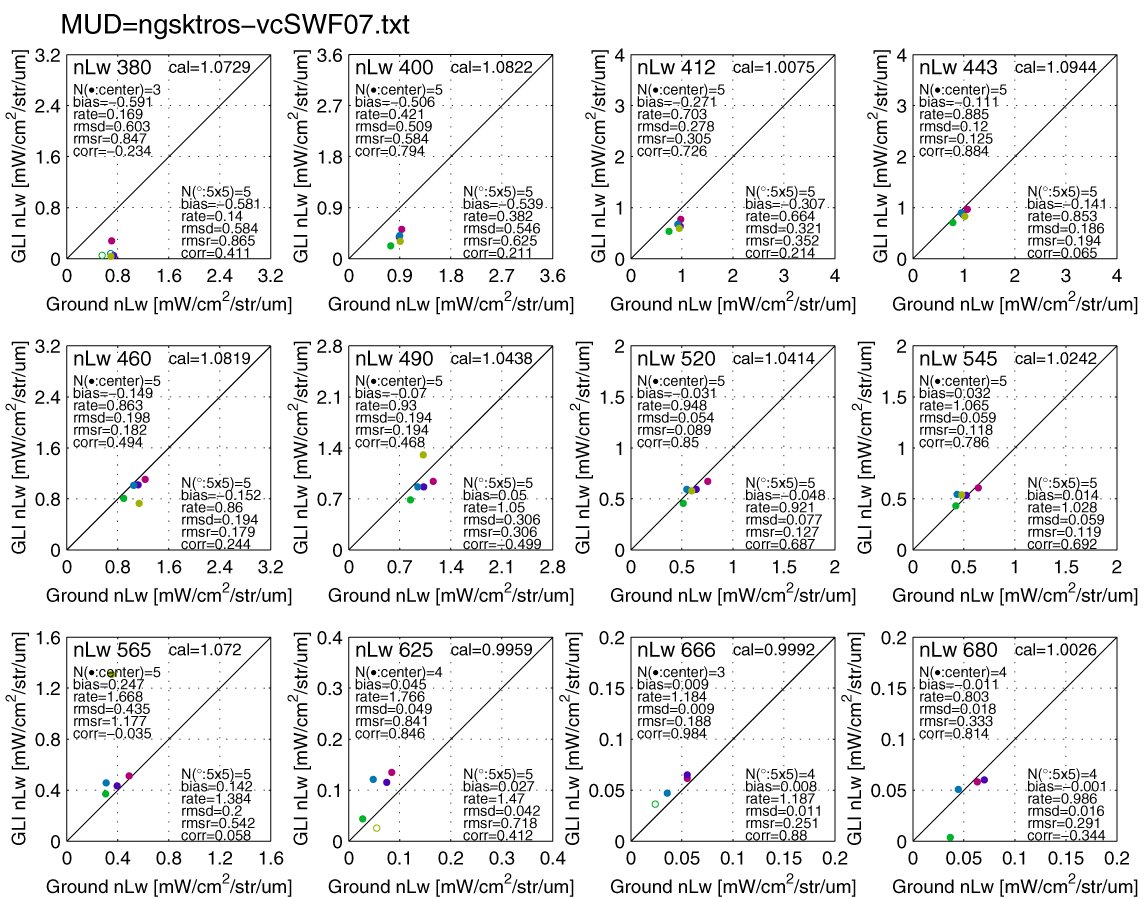
Nagasaki Ferry |
3/20 |
3-5 |
|
|
|
|
|
o |
Ishizaka, Nagasaki Univ |
2.1 | |
|
8 |
ishysmpl20030414 |
4-8 |
0-1 |
|
|
|
|
|
- |
o |
Ishizaka, Nagasaki Univ |
2.1 |
|
9 |
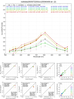
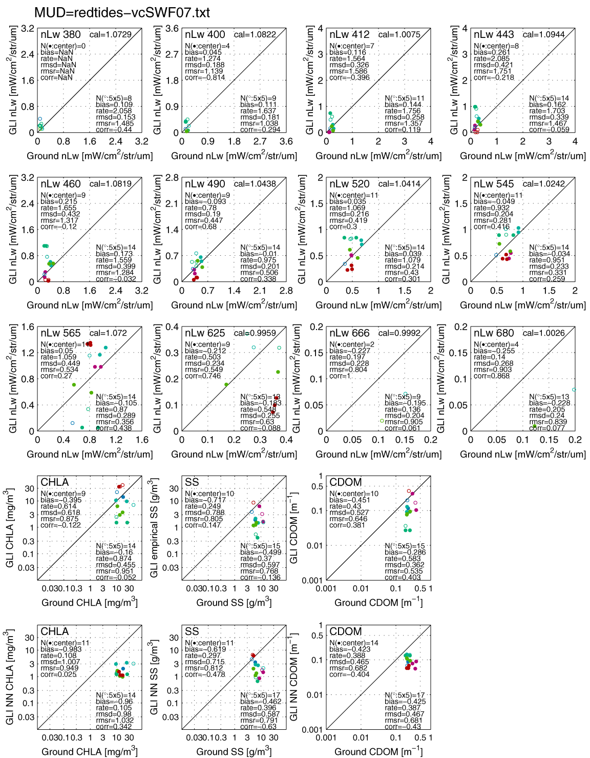
REDTIDE20030722 |
7-8 |
3-12 |
16 |
13 |
14 |
12 |
|
o |
Ishizaka, Nagasaki Univ |
2.1 | |
|
10 |
ishysmpl20031017 |
10/17-18 |
1-3 |
2 |
|
|
3 |
|
o |
Ishizaka, Nagasaki Univ |
2.1 | |
|
11 |
Nagasaki-Maru 03058 |
5/10-13 |
0-1 |
0 |
0-1 |
2-3 |
0-1 |
|
o |
Ishizaka, Nagasaki Univ |
2.1 | |
|
12 |
Nagasaki-Maru 03421 |
4/21-24 |
|
4 |
|
|
|
|
o |
Ishizaka, Nagasaki Univ |
2.1 | |
|
13 |
Kakuyo-Maru 030519 |
5/19-26 |
1 |
2 |
1 |
2 |
1 |
|
o |
Ishizaka, Nagasaki Univ |
2.1 | |
|
14 |
Nagasaki-Maru 030711 |
7/11-17 |
|
1 |
|
|
|
|
- |
o |
Ishizaka, Nagasaki Univ |
2.1 |
|
15 |
Kakuyo-Maru 031017 |
10/17-19 |
4 |
5 |
|
|
4 |
|
o |
Ishizaka, Nagasaki Univ |
2.1 | |
|
16 |
NPEC 200305 |
5-1 |
1-6 |
14 |
9 |
6 |
5 |
|
o |
NPEC, Ishizaka, Nagasaki Univ |
2.1 | |
|
17 |
- |
6-7 |
0-1 |
1 |
1 |
1 |
1 |
|
o |
o |
Ishizaka, Nagasaki Univ |
2.1 |
|
18 |
Tansei-Maru 030711 |
7/1-10 |
|
3 |
|
3 |
|
|
o |
Ishizaka, Nagasaki Univ |
2.1 | |
|
19 |
KH0302 |
10/1-16 |
2-3 |
3 |
|
2 |
|
|
o |
Sasaoka, JAXA/EORC |
2.1 | |
|
20 |
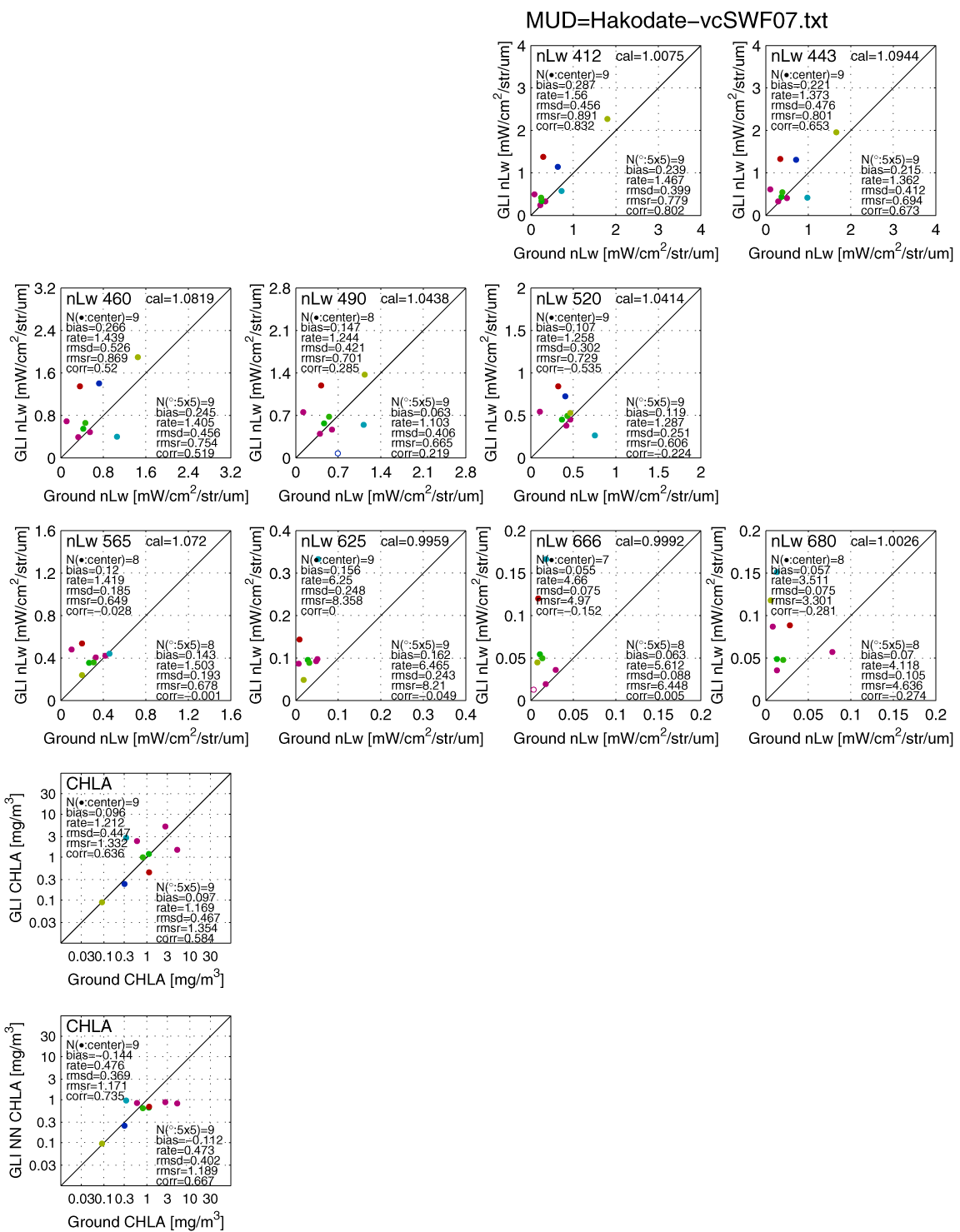
Hakodate |
2-8 |
3-8 |
8 |
|
|
|
|
o |
Saito, Fisheries Sciences and Faculty of Fisheries, Hokkaido Univ. |
2.1 | |
|
21 |
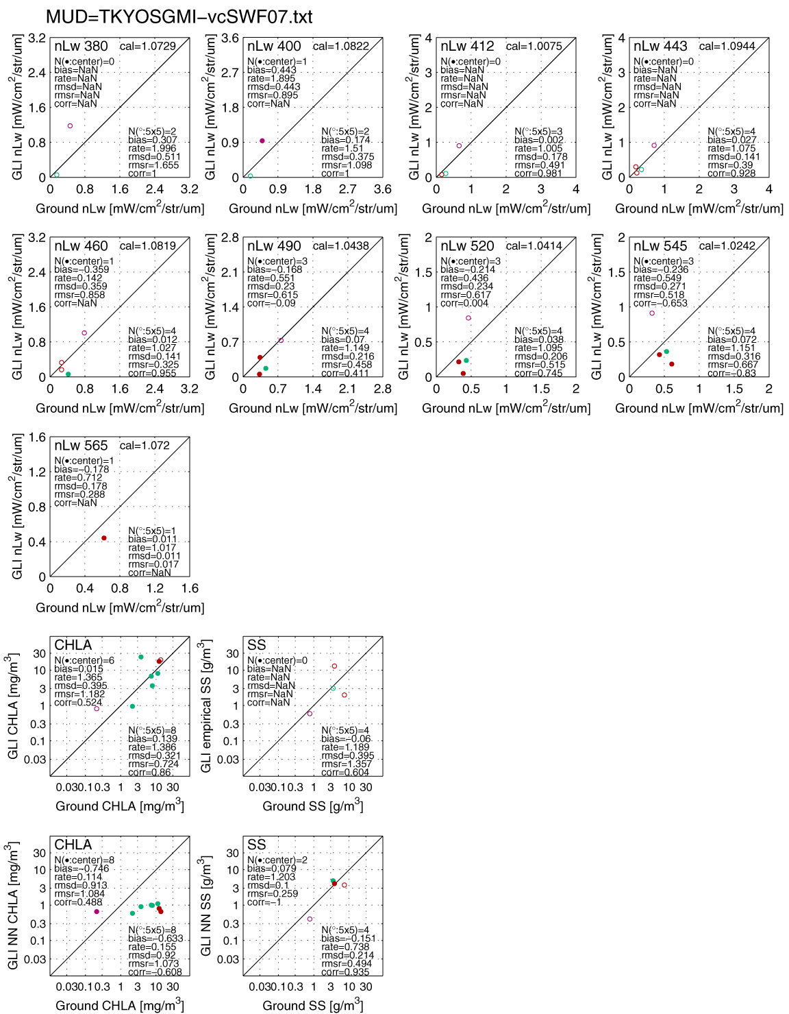
Tokyo&Sagami-Bay |
4/15-18 |
4 |
8 |
4 |
|
|
|
o |
Kishino, Tokyo Kaiyo Univ. |
2.1 | |
|
22 |
New Caledonia |
2-12 |
|
15 |
3 |
3 |
|
|
o |
Dupouy and Neveux, LODYC |
2 | |
|
23 |
Cruise0301 |
4/13-16 |
|
2 |
|
|
|
|
o |
Yokouchi & Kiyomoto, Seikai NFRI |
2.1 | |
|
24 |
Cruise0305 |
7/7-17 |
0-6 |
17 |
|
|
6 |
|
o |
Yokouchi & Kiyomoto, Seikai NFRI |
2.1 | |
|
25 |
YK0306 |
8/1-6 |
0-1 |
|
|
|
0-1 |
|
o |
Yokouchi & Kiyomoto, Seikai NFRI |
2.1 | |
|
26 |
SPINUP |
4-5 |
1 |
5 |
|
|
1 |
|
o |
Saito, Tohoku NFRI |
2.1 | |
|
27 |
SY0306 (off Tohoku) |
5-6 |
|
3 |
|
|
|
|
o |
Tohoku NFRI |
2.1 | |
|
28 |
GOT20031009 |
10/9-26 |
4-10 |
10 |
9 |
10 |
10 |
|
- |
o |
Siripong and Matsumura |
2 |
|
29 |
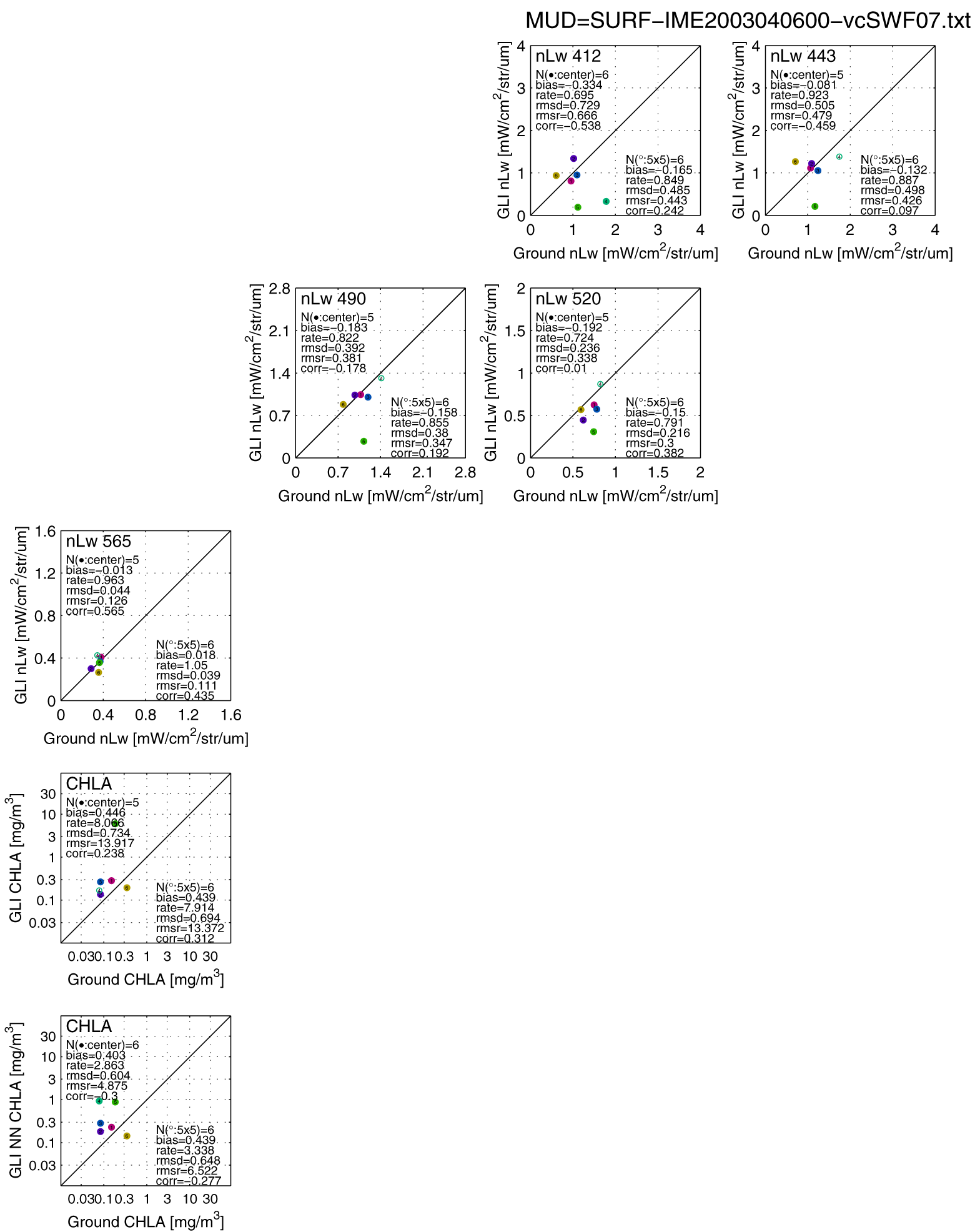
SURF_IME |
4/6-22 |
5 |
5 |
|
|
|
|
o |
B. G. Mitchell, SIO |
3 | |
|
30 |
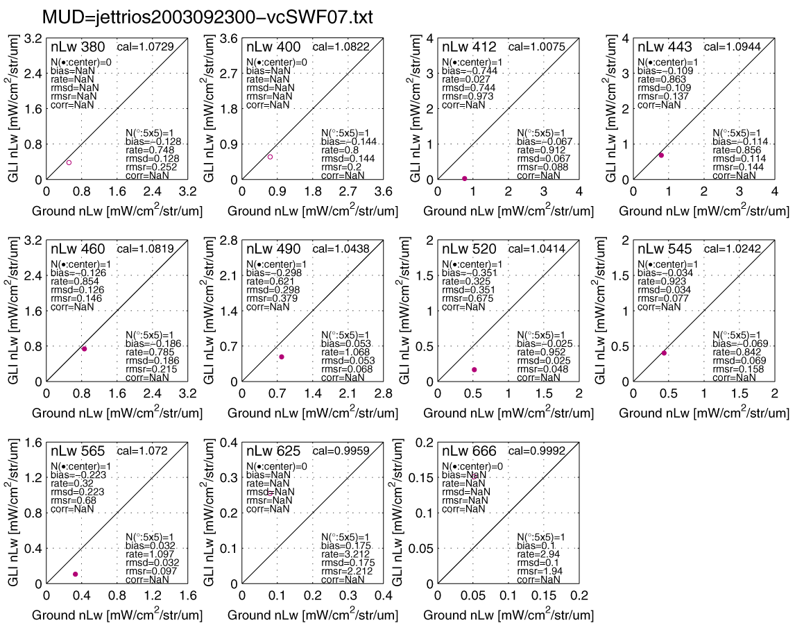
Jetfoil trios 20030923 |
9/23 |
0-2 |
|
|
|
|
|
o |
Ishizaka, Nagasaki Univ |
2 | |
|
31 |
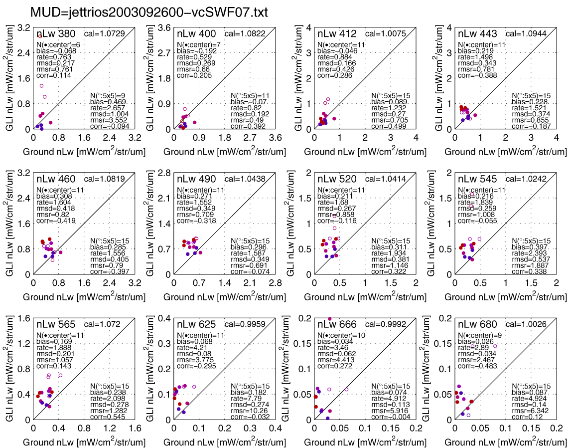
jetfoil trios 20030926 |
9-10 |
9-12 |
|
|
|
|
|
o |
Ishizaka, Nagasaki Univ |
2 | |
|
32 |
Chiba-Monitoirng Post |
5-10 |
|
17 |
|
|
|
|
o |
Japan Coast Guard |
2 | |
|
33 |
HCFES200304 |
4-12 |
|
|
|
|
|
|
|
|
Hokkaido Central Fisheries Experimental Station |
1 |
|
34 |
OsakaBay20030424 |
4-10 |
|
|
|
|
|
|
|
|
National Research Institute of FEIS |
1 |
|
35 |
SY0305&SY0307 |
5-7 |
|
|
|
|
|
|
|
|
National Research Institute of Fisheries Science,Fisheries Research Agency |
2 |
|
36 |
Kurosaki20030817 |
8-9 |
|
|
|
|
|
|
|
|
National Research Institute of Fisheries Science,Fisheries Research Agency |
2 |
|
|
.... |
|
|
|
|
|
|
|
|
|
|
|
P: Levels to open the ground onservation data
[Level-1, 2, 2.5, 3, 4]
1 : open to
only JAXA
2 : open to only JAXA, CAL/VAL PI, and Algorithm
PI
(2.1: open to only JAXA, PI and others only for CAL/VAL/Algorithm
uses)
2.5: same as 2, but will change to 3
3 : open to
JAXA and all PI (CAL/VAL, Algorithm, and earth-science PIs)
4 :
open to public
PRR800: 305, 313, 320, 330, 340, 380, 395, 412,
443, 465, 475, 490, 510, 520, 532, 555, 565, 589, 625, 665, 670, 683, 694, 710,
765, 780 and 875nm
PRR600: 412, 443, 490, 510, 555, and 565
SIMBAD-A:
(350, 380,) 412, 443, 490, 510, 565, 620, 670, 750, and 870nm
(above-water)
SIMBAD-: 443, 490, 560, 670, and 870 nm
(above-water)
MER2041: 340, 380, 412, 443, 465, 490, 520, 538, 565, 585, 625,
663 and 680nm
MER2040: 412, 443, 465, 490, 510, 520, 555, 565, 586, 625, 665
and 680nm
TriOS: above-water mesurements by multi-spectrum from
350~950nm
Additional analysis
*1. Tests of vicarious calibration
coefficients
a-0) original MOBY
result
a-1) test result using temporal and
scan-angle dependent coefficients of mirror-B
a-2)
test
result using temporal and scan-angle dependent coefficients of
mirror-A
a-3)
test result using temporal and
scan angle dependent coefficients of mirror-B corrected by de-stripe
coefs
b) RGB images around
MOBY (PDF file) ,
Mapped image
(PDF file)
~~~~~~~~~~~~~~~~~~~~~~~~~~~~~~~~~~~~~~~~
vicarious coefficients{CH1-19,24,26}=
/* Global
SeaWiFS 20030508-20030711 */
{1.0729, 1.0822, 1.0075, 1.0944, 1.0819,
1.0438, 1.0414,
1.0242, 1.0720, 0.9959, 0.9992, 1.0026, 1.0000,
1.0000,
1.0000, 0.9952, 1.6286, 0.9883, 1.0000, 0.8833,
0.9451},
(old version is
follow)
cp1/0.9966,0.000337/
cp2/1.0109,0.000592/
gcal(14)=cp1(1)+cp1(2)*ptw[mm]*(1/cos(soz)+1/cos(saz))
gcal(15)=cp2(1)+cp2(2)*ptw[mm]*(1/cos(soz)+1/cos(saz))
~~~~~~~~~~~~~~~~~~~~~~~~~~~~~~~~~~~~~~~~~
Tests of in-water algorithm, in-water
model and GLI atmospheric correction (7 April
2004)
 <- please
click Figures (PDF)
<- please
click Figures (PDF)
Upper graphs show ground observed nLws, simulated
nLws, which is calculated by in-water model (by Dr. A.
Tanaka) using ground observed in-water parameters (chla, ss, and cdom), and
GLI nLws, for the cruise #6, #11, #23.
Lower scatter diagrams show difference
between ground observed in-water parameters and estimated ones ("CS"
means results by empirical in-water algorithms using ground observed nLws,
and "GLI" means results using GLI nLws, i.e., GLI products).
Results of "CS"
is geneally much better than "GLI". This means that major error source of GLI in-water products is still atmospheric
correction processing.
However, differences between simulated nLws
and observed nLws are also large (see upper graph or right scatter
diagrams). This means that the in-water model also has some
problem, especially on backscattering coefficients of chla, and should be
improve for improving in-water neural network algorithm and for estimating
realistic nLws in the atmospheric correction processing.
for reference,
RGB images of GLI match up data #11:Kakuyo-Maru
030519, #23:NPEC 200305, #6:REDTIDE(July)
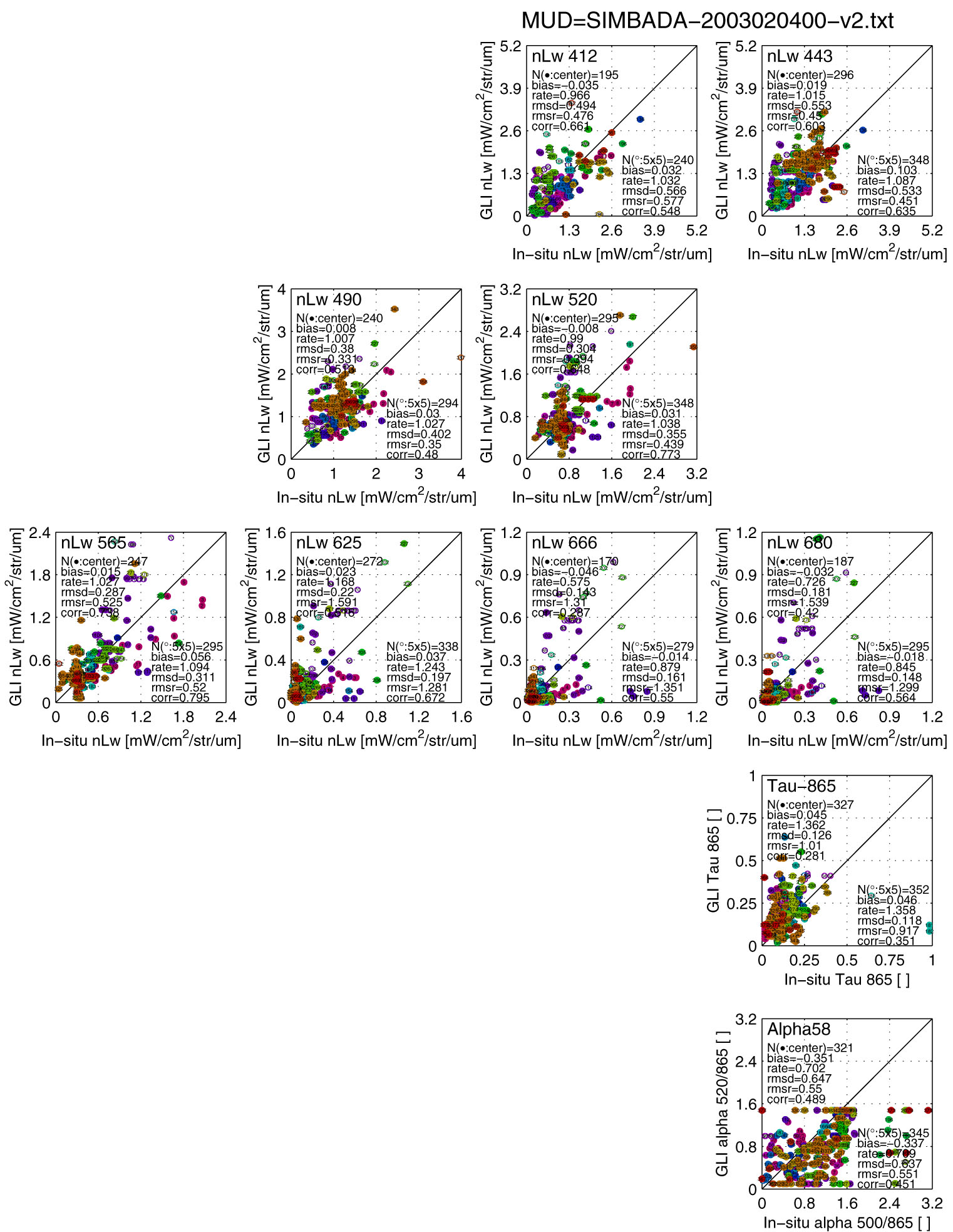
GLI match-up to the SIMBAD-A observations by
Univ. Lille group (11 June 2004)
Scatter plots of each
cruise (PDF)
Match-up locations of
each cruise (PDF)
ID=
1 COLIBRI-2003-04
ID=
2
LI_PRO-1
ID=
3
MEDGOOS-6
ID=
4
NORBAL-5
ID= 5
heincke-2003
ID= 6
skogafos-2003
ID=
7
boussole21
ID= 8
Belgica-2003-11
ID= 9
niva-cruise-#01
ID= 10
COLIBRI-2003-04
ID=
11
LI_PRO-1
ID= 12
heincke-2003
ID=
13 boussole22
ID=
14 niva-cruise-#02
ID=
15 Belgica-2003-16
ID=
16 niva-cruise-#02
ID=
17 COLIBRI-2003-07
ID=
18 GKSS-2003-07
ID=
19 boussole24
ID=
20 Belgica-2003-07
ID=
21 BLACK-SEA-2003
ID=
22 COLIBRI-2003-07
ID=
23 GKSS-2003-07
ID=
24 Belgica-2003-08
ID=
25 TOUCAN-2003-11
ID=
26 LIGUR-2003
ID=
27 Belgica-2003-09
ID=
28 TOUCAN-2003-11
 H. Murakami