Land Surface Temperature (LST)
[DOI: 10.57746/EO.01gs73b3gb1c3evfz28g98tc1f]
Introduction
| LST | Define | Temperature of terrestrical land surface. |
| Unit | Kelvin | |
| ATBD |
Ver.1 (Sep. 2014) Ver.2 (May 2020) Ver.3 (Jun. 2021) |
Update contents of Ver.2
- ・Added input data(CLFG)
- ・Modified QA flag
Update contents of Ver.3
- ・Modified cloud screening level using QA_flag
- ・Modified QA_flag (Error_DN)
- ・Modified Mask_for_statistics
Sample image
| File format | Ver.1 | Ver.2 | Ver.3 | hdf5 |
TBU |
LST_Q(250m) |
LST_Q(250m) |
|---|---|---|---|
| JPEG |
TBU |
LST_Q(250m) |
LST_Q(250m) |
Dataset name
| Ver.1,2,3 | Description |
|---|---|
| E01 | Land Surface Emissivity @ TI01 |
| E02 | Land Surface Emissivity @ TI02 |
| LST | Land Surface Temperature |
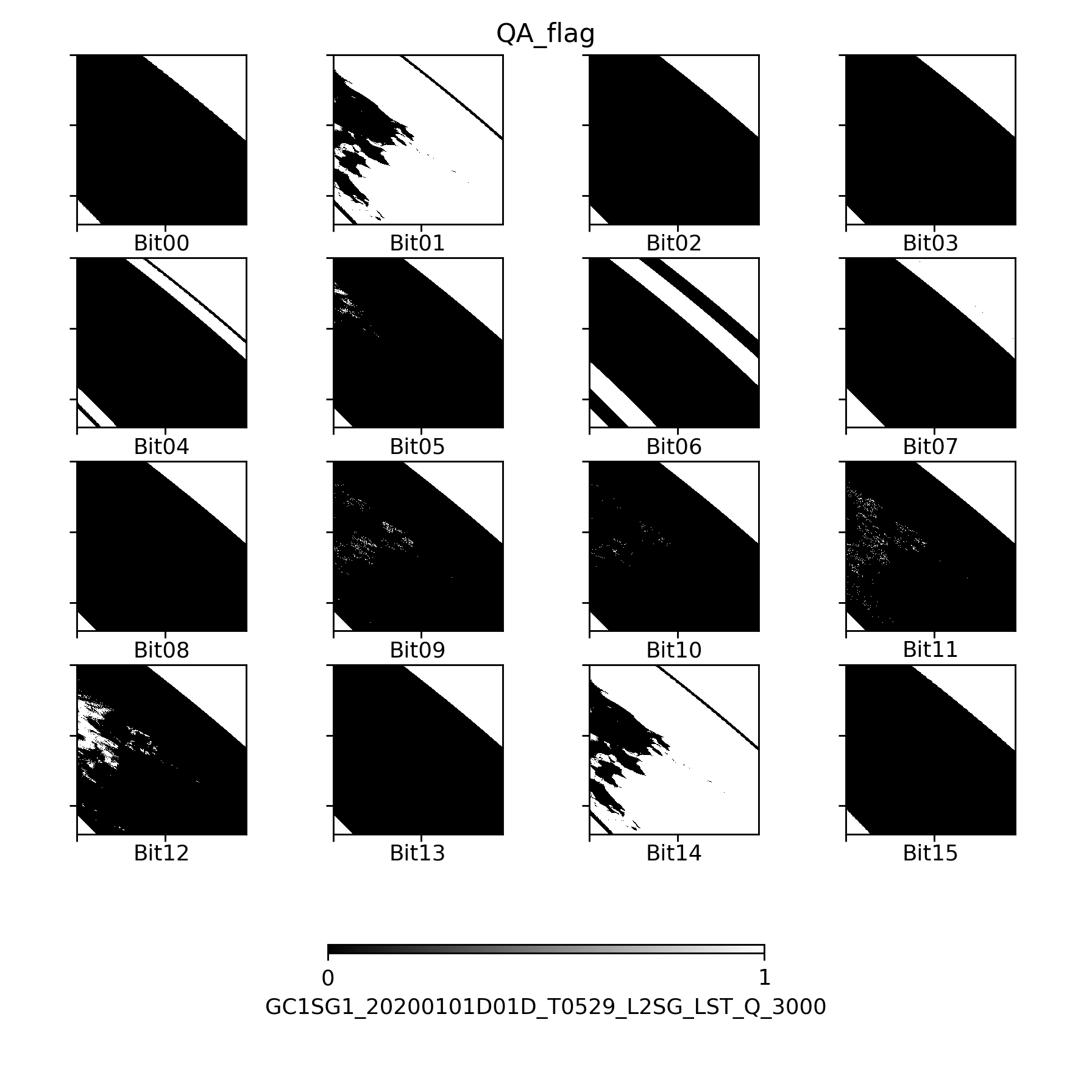
| QA_flag |
QA_flag information
Ver.1 Ver.2 Ver.3 Ver.1(Sample Image) Ver.2(Sample Image) Ver.3(Sample Image)
| Bit | ver1 | Description | E01_L3_mask* | E02_L3_mask* | LST_L3_mask* |
|---|---|---|---|---|---|
| 0 | no input data | 0:no_data, 1:valid data | 1 | 1 | 1 |
| 1 | land/water flag(0=land/1=water) | 0:land, 1:water | 1 | 1 | 1 |
| 2 | Spare | 0 | 0 | 0 | |
| 3 | Spare | 0 | 0 | 0 | |
| 4 | no VNR/SWR | 1:VNR/SWIR no_data | 1 | 1 | 1 |
| 5 | Snow | 0 | 0 | 0 | |
| 6 | Sensor zenith angle > 33 | 1:yes | 0 | 0 | 0 |
| 7 | Sensor zenith angle > 43 | 1:yes | 0 | 0 | 0 |
| 8 | TR1 < 0.6 | 0 | 0 | 0 | |
| 9 | RES > 1[K] | (CNVERR>1.0)&&(CNVERR<= 2.0) | 0 | 0 | 0 |
| 10 | RES > 2[K] | CNVERR> 2.0 | 0 | 0 | 0 |
| 11 | Probably Cloudy | 1 | 1 | 1 | |
| 12 | Cloudy | 1 | 1 | 1 | |
| 13 | TS out of range | (TS<173.15) ||(TS>370.0) | 1 | 1 | 1 |
| 14 | land/water flag(0=land/1=water) | 0:land, 1:water | 1 | 1 | 1 |
| 15 | no input data | 0:no_data, 1:valid data | 1 | 1 | 1 |
* Bits masked by statistical processing are indicated by 1.
Please refer to here to the detail information for QA flag.
| Bit | ver2 | Description | E01_L3_mask* | E02_L3_mask* | LST_L3_mask* |
|---|---|---|---|---|---|
| 0 | no input data | 0:no_data, 1:valid data | 1 | 1 | 1 |
| 1 | land/water flag(0=land/1=water) | 0:land, 1:water | 1 | 1 | 1 |
| 2 | Spare | 0 | 0 | 0 | |
| 3 | no CLFG | 1:yes | 0 | 0 | 0 |
| 4 | no VNR/SWR | 1:VNR/SWIR no_data | 1 | 1 | 1 |
| 5 | Snow | 0 | 0 | 0 | |
| 6 | Sensor zenith angle > 33 | 1:yes | 0 | 0 | 0 |
| 7 | Sensor zenith angle > 43 | 1:yes | 0 | 0 | 0 |
| 8 | TR1 < 0.6 | 0 | 0 | 0 | |
| 9 | RES > 1[K] | (CNVERR>1.0)&&(CNVERR<= 2.0) | 0 | 0 | 0 |
| 10 | RES > 2[K] | CNVERR> 2.0 | 0 | 0 | 0 |
| 11 | Probably Cloudy | 1 | 1 | 1 | |
| 12 | Cloudy | 1 | 1 | 1 | |
| 13 | TS out of range | (TS<173.15) ||(TS>370.0) | 1 | 1 | 1 |
| 14 | land/water flag(0=land/1=water) | 0:land, 1:water | 1 | 1 | 1 |
| 15 | no input data | 0:no_data, 1:valid data | 1 | 1 | 1 |
* Bits masked by statistical processing are indicated by 1.
Please refer to here to the detail information for QA flag.
| Bit | ver3 | Description | E01_L3_mask* | E02_L3_mask* | LST_L3_mask* |
|---|---|---|---|---|---|
| 0 | no input data | 0:no_data, 1:valid data | 1 | 1 | 1 |
| 1 | land/water flag(0=land/1=water) | 0:land, 1:water | 1 | 1 | 1 |
| 2 | Spare | 0 | 0 | 0 | |
| 3 | no CLFG | 1:yes | 0 | 0 | 0 |
| 4 | no VNR/SWR | 1:VNR/SWIR no_data | 1 | 1 | 1 |
| 5 | Snow | 0 | 0 | 0 | |
| 6 | Sensor zenith angle > 33 | 1:yes | 0 | 0 | 0 |
| 7 | Sensor zenith angle > 43 | 1:yes | 0 | 0 | 0 |
| 8 | TR1 < 0.6 | 0 | 0 | 0 | |
| 9 | RES > 1[K] | (CNVERR>1.0)&&(CNVERR<= 2.0) | 0 | 0 | 0 |
| 10 | RES > 2[K] | CNVERR> 2.0 | 0 | 0 | 0 |
| 11 | Probably Cloudy | 0 | 0 | 0 | |
| 12 | Cloudy | 1 | 1 | 1 | |
| 13 | TS out of range | (TS<173.15) ||(TS>370.0) | 1 | 1 | 1 |
| 14 | land/water flag(0=land/1=water) | 0:land, 1:water | 1 | 1 | 1 |
| 15 | no input data | 0:no_data, 1:valid data | 1 | 1 | 1 |
* Bits masked by statistical processing are indicated by 1.
Please refer to here to the detail information for QA flag.
*Download:QA_flag(Ver.1)


Attribute information
How to use
- ・Physical quantity=DN*slope + offset
- ・Valid values are during Minimum_valid_DN~Maximum_valid_DN
