|
|
|
-->[TOC] [INTRO] [DOCS] [OVERVIEW]
[ADEOS HOME]
AVNIR CEOS TAPE FORMAT
- Introduction
- D-1 Cassette Specifications
- Logical Volume Structure on D-1 Cassette
- Volume Descriptor Record Contents
- File Pointer Record Contents
- Text Record Contents
- Common File Descriptor Record Contents
- Leader File Descriptor Record Contents
- Scene Header Record Contents
- Definition of Orientation Angles
- Map Projection Ancillary Record Contents
- Radiometric Ancillary Record Contents
- Ephemeris Ancillary Record Contents
- Telemetry Ancillary Record Contents
- Image File Descriptor Record Contents
- Image Data Record Contents
- Trailer File Descriptor Record Contents
- Trailer Record Contents
Introduction
This appendix describes the format for D-1 Cassettes produced by the ADEOS AVNIR Processing Subsystem (AAPS). The format is derived from the JERS-1 OPS format described in Document R-4.D-1 Cassette Specifications
A D-1 cassette (or more precisely, the D-1M cassette) is the data storage medium which will be used by the ADEOS project to store data received and processed by the AAPS. The tape will be written by a SONY DIR-1000L recorder with a SONY DFC-1500 fast SCSI-2 interface.The total capacity of one of the D-1M cassette is approximately 40 gigabytes, however 5% (~2 gigabytes) of the tape is not used for writing and another 10% (4 gigabytes) is lost utilizing its emulation format mode. Therefore, the total usable capacity of the D-1M cassette is approximately 34 gigabytes.
Logical Volume Structure on D-1 Cassette
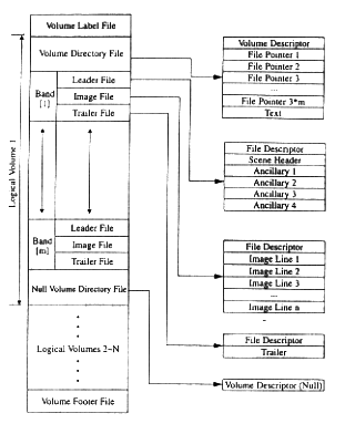
Each image product on a D-1 cassette is referred to as a logical volume. The contents of a typical logical volume is illustrated in Figure B-1 through Figure B-2. Note that Figure B-3 and Figure B-4 are merely special cases of the generic layouts as shown in Figure B-1 and Figure B-2 respectively. As is shown, the data files are logically grouped on a tape (D-1 cassette) and the individual cassettes are the physical volumes. Due to the large capacity of a D-1 cassette, a logical volume will always be contained within a single physical volume. Furthermore, a physical volume may contain many logical volumes.
File Record Arrangement for BSQ Format products
File Record Arrangement for BSQ Format products containing output for m bands numbered Band [l] to Band [m], where is 1,2,3 or 3. Note that this layout will be used for normal multispectral and panchromatic products only.
File Record Arrangement for BIL Format products

File Record Arrangement for BIL Format products containing output for m bands numbered Band [l] to Band [m], where m is 1,2,3 or4 Note that this layout will be used for normal multispectral and panchromatic products only.
File Record Arrangement for BSQ Format Mu/Pan HIS Merged products

File Record Arrangement for BSQ Format Mu/Pan HIS Merged products containing output for the 3 merged multispectral band numbered Band [l] to Band [3]. The first Ancellary 4 record, marked with (a) pertains to the Multispectral band, while the second Ancillary 4 record, marked with (b), pertains to the Panchromatic band.
File Record Arrangement for BIL Format Mu/Pan HIS Merged product
File Record Arrangement for BIL Format Mu/Pan HIS Merged products containing outprt for the 3 merged multispectral bands numbered Band [l] to Band [3]. The first Ancillary 4 record, marked with (a), pertains to the Multispectral band, while the second Ancillary 4 record, marked with (b), pertains to the Panchromatic band.
Note that the ordering of per band data is based on a "band list" which is an array of length "m" containing the actual "band numbers" and is denoted by the syntax Band [1], Band [2],...,Band [m]. The product will therefore contain the per band data for the m bands inthe order as specified by this band list.
In the case of a multispectral product, it will have a band list of length 4, containing the band numbers 1,2,3,4. Refer to Figure B-1 and Figure B-2.
In the case of a panchromatic product, it will have a band list of length 1, containing the band number 5. Refer to Figure B-1 and Figure B-2.
In the case of a Mu/Pan HIS merged product, it will have a band list of length 3, containing all the bands specified in the product order, but in ascending band number order. For example, the band list will contain 1, 2, 3, 4 for a product order requiring bands 4, 2 and 1 as red, green and blue colours respecively. Refer to Figure B-3 and Figure B-4.
At the highest level of organization, a logical volume of data written in the standard format may be seen to consist of an introductory file (the volume derectory) and the set of data files (leader, image, and trailer), followed by a terminating file ( the null volume directory file). The null volume directory file consists of a null volume descriptor record only and marks the end of a logical volume. Any subsequent logical volumes of data (2-N on this physical volume) would have their volume directories following the null volume directory file of the preceding logical volume. A description of these files and their component record names is given below. Also, a Volume Label file and a Volume Footer file will be written at the beginning at end of the D-1 cassette. These files give information about the contents of the tape as well as the physical position of the next file to be written to tape. The formats of the Volume Label File and Volume Footer File are specified in the D1 Cassette format specification.
Description of Product Composition
File Name Description Component Record Name(s) Volume Directory File This file is located at the beginning of a logical volume and stores the volume and file management information. Volume Descriptor
File Pointer
TextLeader File This file is located before the image file and stores information related to the image data (e.g. annotation data, ancillary data, etc.). File Descriptor
Scene Header
AncillaryImage File This file is located after the leader file and contains the image data. File Descriptor
ImageTrailer File This file is located after the image file and stores final information on the image data. File Descriptor
TrailerNull Volume This is the last file within the logical volume. Volume Descriptor (Null) The volume directory file defines the logical and physical construction of the volume. Within the volume directory file, the first record is a volume descriptor record. This is followed by one file pointer record for each data file within the logical volume(3 for BIL and '3*m' for BSQ -- m<4), which is used to define the logical construction of that data file. This is followed by a text record, which serves only as a descriptive record stored in alphanumeric form.
Within each data file, the record is a file descriptor record containing detailed information on how to interpet the contents of its consituent records. In addition, each file has associated with it a file class, to identify the broad category to which the data belongs. Futhermore, within each data record, the first six fields (twelve bytes) are normally used to specify that record's sequence number within the file, some record type coding information, and the length of the record.
Logical Volume Records
In this section the formats of the following eight record tapes are detailed:Note that, for the indicated tables, the following terminology applies:
- Volume Descriptor
- File Pointer
- Text
- File Descriptor (Common File, Leader File, Image File, and Trailer File)
- Scene Header
- Ancillary (Map Projection, Radiometric, Ephemeris, Telemetry)
- Image
- Trailer
- 'b' indicates that the contents of that particular byte should be filled with a blank space ('b~b' indicates that the rest of a particular field should be filled with blanks).
- A 'Blank' field corresponds to all 'b' for character fields.
- For merged products (multispectral and panchromatic), any times relating to scene times shall correspond to the multispectral band.
Record Data Types
Data types are used to explain these records and can be defined as per Table B-2. Note that "m" represent the number of digits displayed, "n" represents the number of digits after the decimal point, and "p" represents the power of the exponent.
Type
(Abbrev.)Description Am Character display (left justified unless otherwise specified). Im ASCII character string representing an integer (right justified). Fm.n Real type data display (right justified). Gm.nEp Real type data display (exponential - right justified). Bm Binary display (most significant byte first). Record Type Codes and Record Subtype Codes
Each record contains a record type code and a record subtype code (hereinafter referred to as the "subtype code") to distinguish it from other records. The thpe codes for each record is given in .
Record Name First Record Subtype Record Record Subtype Second Record Subtype Third Record Subtype Record Length (bytes) Volume Descriptor 300|8 300|8 022|8 022|8 360|8 File Pointer 333|8 300|8 022|8 022|8 360|8 Text 022|8 077|8 022|8 022|8 360|8 File Descriptor 077|8 300|8 022|8 022|8 Variable Null Volume Descriptor 300|8 300|8 077|8 022|8 360|8 Scene Header 022|8 022|8 022|8 011|8 4680|8 Map Projection Ancillary 044|8 044|8 022|8 011|8 4680|8 Radiometric Ancillary 077|8 044|8 022|8 011|8 4680|8 Ephemeris Ancillary 366|8 044|8 022|8 011|8 4680|8 Telemetry Ancillary 055|8 044|8 022|8 011|8 4680|8 Image Data 355|8 355|8 222|8 022|8 Variable Trailer 022|8 366|8 022|8 011|8 4680|8 Record Content Definitions
Volume Descriptor Record Contents
Field # Byte #(s) Data Type Description (Definition and Value) 1 1-4 B4 Record No. = 1|10 2 5 B1 The first subtype code = 300|8 3 6 B1 Record type code = 300|8 4 7 B1 The second subtype code:
Volume Descriptor = 022|8
Null Volume Descriptor = 077|85 8 B1 The third subtype code = 022|8 6 9-12 B4 Record Length = 360|10 7 13-14 A2 ASCII code character = 'Ab' 8 15-16 A2 Blank 9 17-28 A12 Specification (= "CCB-CCT-0003"). See clarifications at the end of this table. 10 29-30 A2 Revision no. of specification. See clarifications at the end of this table. 11 31-32 A2 Record format revision no. See clerifications at the end of this table. 12 33-44 A12 Software version no.= 'UVWb~b'
U : Version of distortion correction (='0'~'9', 'A'~'Z')
V : Blank
W : Database version (='0'~'9', 'A'~'Z')13 45-60 A16 Tape ID = 'DSSMXXXXXXLLLUVW'
D : Medium Type ='D'(D-1 Cassette)
SS : System Code(11 : Recording System, 12 : Processing System)
M : Master/Work distinction(0-8:Master, 9: Work)
XXXXX :Scheme number
LLL : Location on Tape
U : Sensor identifier (="A")
V : Number of tapes in volume set (="1")
W : Sequential volume number inset (="1")14 61-92 A32 Product ID = 'XXXXXXXXXX-TTT-NN-
FFFb~b'
XXXXXXXXX :Production control number
TTT : Production control technical number
NN : Relative product number
FFF : Format ('BSQ' or 'BIL')15 93-94 I2 Number of physical tapes in the logical volume for one scene (= 'b1') 16 95-96 I2 D-1 Cassette's first volume no. for one scene ='b1' 17 97-98 I2 D-1 Cassette's last volume no. for one scene ='b1' 18 99-100 I2 Volume number of this volume descriptor record = 'b1' 19 101-104 I4 Number of first file following the volumedirectory file = 'bbb1'. For Null volume descriptor, all shall be blank. 20 105-108 I4 Logical volume number in volume set (within one scene onthe D-1 Cassette)= 'bbb1'
Null volume descriptor = 'bbb2'21 109-112 A4 Blank 22 113-120 A8 Logical Volume preparation date = 'YYYYMMDD'
YYYY :A.D. year
MM :Month
DD :Day23 121-128 A8 Logical Volume preparation time(GMT) = 'HHMMSSXX'
HH : Hour
MM : Minute
SS : Second
XX : milliseconds ('10's)24 129-140 A12 Logical Volume preparation country = 'JAPANb~b' 25 141-148 A8 Logical Volume preparing agent = 'NASDAbbb' 26 149-160 A12 Facility for preparing logical volume = 'EOC-ADEOSDPS' 27 161-164 I4 Number of file pointer records in volume directory file = 'bbb3' ~ 'bb12'
Null volume descriptor = 'bbbb'28 165-168 I4 Number of records in volume directory file = 'bbb5' ~ 'bb14'
Null volume descriptor = 'bbbb'29 169-360 A192 Blank Clarifications - Volume Descriptor Record
- Fields #9-11 (Specification and version numbers)
The values for these fields are specified in system parameter files, and may therefor be configured by the operating agency (NASDA) to any arbitrary values.
- Field #12 (Software Version Number)
The values U and W (Version of distortion correction and database version respectively) are derived from values in the Version database table as described in the AAPS External Interface Specification (Document A-1), as follows:
U = "sum" of AVNIR_H and AVNIR_P;
W = "sum" of AVNIR_CTRL, AVNIL_CONST, AVNIR_SENSOR and AVNIR CAL.
For the purposes of adding the alphanumeric characters, the digits '1' to '9' will be mapped to their numeric equrivalents (i.e. the values 1 to 9), and the letters 'A' to 'Z' will be mapped to the values 10 through 35. A single digit resulting "sum" is derived by mapping the result of the following computation onto the characters '1' to 'A' to 'Z' using the above mappings: "som" = (((SUMversions)-1)mod 35) +1File Pointer Record Contents
Field # Byte#(s) Data Type Description (Definition and Value) 1 1-4 B4 Record number BSQ =02|10~13|10
BIL =02|10~04|102 5 B1 The first Subtype code =333|8 3 6 B1 Record type code = 300|8 4 7 B1 The second subtype code =022|8 5 8 B1 The third subtype code = 022|8 6 9-12 B4 Record Length =360|10 7 13-14 A2 ASCII code character = 'Ab' 8 15-16 A2 Blank 9 17-20 I4 File number of this file pointer record = 'bbb1'~ 'bb12' 10 21-36 A16 File ID indicated by this file pointer ='LLNbSSSTFFFFXXXB'
LLL : Satellite code (='AD')
N : Mission number (='1')
SSS : Sensor type ='AVM' :Multispctral
='AVP' : Panchromatic
='ABC' : Mu/Pan HIS MergedT : Data type ='0'~ '3' : Correction Level
='0' : raw(AVNIR Level 1A)FFFF : File type ='LEAD' :Leader File
='IMGY' : Image File
='TRAI' : Trailer FileXXX : Image format (='BSQ' or 'BIL')
B : Band ='1'~ '4' :Multispectral BSQ
='P' : Panchromatic BSQ
=blank rof BILNOTE : in the case of a BSQ HIS merged product, this is the band of the multispectral image.
11 37-64 A28 File class indicated by this file pointer
Leader file = 'LEADERb=b'
Image file = 'IMAGER Ybbbbbbbbb~b'
Trailer file =TRAILER b~b'12 65-68 A4 File class code indicated by this file pointer
Leader file ='LEAD'
Image file ='IMGY'
Trailer File ='TRAI'13 69-96 A28 File data type shown in the fise pointer (='MIXEDbBINARYbANDbASCIIb~b' except, ='BINARYbONLYb~b' for the image files) 14 97-100 A4 File data type code shown in this file pointer record (='MBAA' except, ='BINO' for image file) 15 101-108 I8 Number of records in the file shown in this file pointer record: The leader file will normally consist of 6 records. In the case of Mu/Pan HIS Merged products, two Ancillary 4 records are included, the first for the Mu band and the second for the Pan band.
Record # Number of records BSQ 1,4,7,10
2,5,8,11
3,6,9,126 or 7*
n + 1
2BIL 1
2
36 or 7*
n*(#bands) + 1
2 ~ 616 109-116 I8 The first record length of the file shown in this file pointer record. 17 117-124 I8 The maximum record length (byte length) in this file pointer record (Same as field #16) 18 125-136 A12 Record length type in the file shown in this file pointer record ='FIXEDbLENGTH' 19 137-140 A4 Record length type code in the file shown in this file pointer record ='FIXD' 20 141-142 I2 Volume number containing the first record in the file shown in this file pointer record ='b1' 21 143-144 I2 Volume number containing the final record in the file shown in this file pointer record ='b1' 22 145-152 I8 The first record number of the referenced file within the volume containing this record ='b~b1'. 23 153-360 A208 Blank Text Record Contents
(NOTE: in the case of the Mu/Pan HIS merged products, this record reports information corresponding to the multispectral image, unless otherwise stated specifically)
Field # Byte #(s) Data Type Description (Definition and Value) 1 1-4 B4 Record number BSQ =05|10~14|10
BIL =05|102 5 B1 The first Subtype code =022|8 3 6 B1 Record type code =077|8 4 7 B1 The second subtype =022|8 5 8 B1 The third subtype code =022|8 6 9-12 B4 Record Length =360|10 7 13-14 A2 ASCII code character ='Ab' 8 15-16 A2 Blank 9 17-66 A50 Product Type = 'SSSLLNSNNNNSNNNYYDDDCCCb~b'SSS : Sensor type='AVM': Multispectral
='AVP': Panchromatic
='AVC': Mu/Pan HIS Merged
LL : Satellite code (='AD')
N : Mission number (='1')
SNNNN : GRS column number
SNNN : GRS line number
YY : Preparation year (last two digits)
DDD : Preparation dey (in Caesarean calendar)
CCC : Processing level = '1Ab', '1B1', and '1B2'10 67-124 A58 Facility for preparing product and preparation date ='EOC - ADEOSDPSbYYMMDDHHNNSSb~b'
YY : Preparation year (last two digits)
MM : Month
DD : Day
HH : Hour
NN : Minute
SS : Second11 125-134 A10 Scene ID (scene center time) = 'MDDDDHHNNS'
M : Mission number (='1')
DDDD : Number of days passed after launching of satellite
HH : Observation time (Houra)
NN : Observation time (Minute)
S : Observation time (in 10's of seconds)12 135-136 A2 Blank 13 137-140 A4 Blank 14 141-144 A4 Image format (='BDQb' or 'BILb') 15 145-360 A216 Blank Common File Descriptor Record Contents
Field # Byte #(s) Data Type Description (Definition and Value) 1 1-4 B4 Record number =1|10 2 5 B1 The first Subtype code=077|8 3 6 B1 Record type code =300|8 4 7 B1 The second subtype code =022|8 5 8 B1 The third subtype code =022|8 6 9-12 B4 Record Length =4680|10 (Variable for image file) 7 13-14 A2 ASCII code character ='Ab' 8 15-16 A2 Blank 9 17-28 A12 Manual for logical volume format (File document number). See clarifications at the end of this table. 10 29-30 A2 Revision number of manual for logical volume format. See clarifications at the end of this table. 11 31-32 A2 Revision number of logical volume layout (File design revision letter). See clarifications at the end of this table. 12 33-34 A12 Logical volume preparation system release number ("HDPSFA01bbbb") 13 45-48 I4 File number. The volume directory file is excluded.
Leader File Image File Trailer File BSQ Band [1] 1 23 BSQ Band [2] 4 56 . . .. . . .. Band [M] . .. BIL 1 2 3 14 49-64 A16 File ID = 'AD1bSSSTFFFFXXXB'
Contents same as for field #10 in the File Pointer record.15 65-68 A4 Record composition flag = 'FSEQ' 16 69-76 I8 Record number position of each file ='b~b1' 17 77-80 I4 Field length (bytes) for record data= 'bbb4' 18 81-84 A4 Specified flag of record type code = 'FTYP' 19 85-92 I8 Byte position of record type code = 'b~b5' 20 93-96 I4 Record type code field length ='bbb4' 21 97-100 A4 Specified flag of record length ='FLGT' 22 101-108 I8 Byte position of record length ='b~b9' 23 109-112 I4 Number of bytes of record length ='bbb4' 24 113 A1 Flag for data converion information in the file descriptor record ='N' (i.e., not included) 25 114 A1 Flag for data converion information in the records other than the file descriptor record ='N' (i.e., not included) 26 115 A1 Flag for data display information in the file descriptor record ='N' (i.e., not included) 27 116 A1 Flag for data display information in the records other than the file descriptor record ='N' (i.e., not included) 28 117-180 A64 Blank 29 181- Continuation of specific file descriptor. Refer to tables for respective file descriptors. Clarifications - Common File Descriptor Record
- Fiellds #9-11 (Logical volume format manual and reversion numbers) The values for these fields are specified in system parameter files, and may therefore be configured by the operating agency (NASDA) to any arbitrary values.
Leader File Descriptor Record Contents
(NOTE: in the case of the Mu/Pan HIS merged products, this record reports information corresponding to the multispectral image, unless otherwise stated specifically)
Field # Byte #(s) Data Type Description (Definition and Value) 1 1-180 Common file descriptor. 2 181-186 I6 Number of scene header records ='bbbbb1' 3 187-192 I6 Length of scene header record ='bb4680' 4 193-198 I6 Number of ancillary records ='bbbbb4' or 'bbbbb5'. Normally, there is only 4 ancillary records, however in the case of Mu/Pan HIS Merged products, there are two Ancillary 4 records, the first for the Mu band and the second for the Pan band. 5 199-204 I6 Len gth of ancillary record ='bb4680' 6 205-210 A6 Blank 7 211-216 A6 Blank 8 Scene ID field locator: 8.1 217-222 I6 Record Number ='bbbbb2' 8.2 223-228 I6 Data start byte number ='bbbb37' 8.3 229-231 I3 Number of bytes ='b16' 8.4 232 A1 Data type ='A' 9 RSP ID locator : 9.1 233-238 I6 Record Number ='bbbbb2' 9.2 239-244 I6 Data start byte number ='bbb165' 9.3 245-247 I3 Number of bytes ='b16' 9.4 248 A1 Data type ='A' 10 Mission ID locator : 10.1 249-254 I6 Record Number ='bbbbb2' 10.2 255-260 I6 Data start byte number ='bbb309' 10.3 261-263 I3 Number of bytes ='b16' 10.4 264 A1 Data type ='A' 11 Sensor ID locator : 11.1 265-270 I6 Record Number ='bbbbb2' 11.2 271-276 I6 Data start byte number ='bbb325' 11.3 277-279 I3 Number of bytes ='b16' 11.4 280 A1 Data type ='A' 12 Scene center time locator : 12.1 280-286 I6 Record Number ='bbbbb2' 12.2 287-292 I6 Data start byte number ='bbb117' 12.3 293-295 I3 Number of bytes ='b32' 12.4 296 A1 Data type ='A' 13 Scene center latitude/ longitude locator : 13.1 297-302 I6 Record Number ='bbbbb2' 13.2 303-308 I6 Data start byte number
='bbb53' :Levels 1A and 1B1
='bbb213 :Levels 1B213.3 309-311 I3 Number of bytes ='b32' 13.4 312 A1 Data type ='N' 14 Processing level locator : 14.1 313-318 I6 Record Number ='bbbbb2' 14.2 319-324 I6 Data start byte number ='bbb1573' 14.3 325-327 I3 Number of bytes ='b16' 14.4 328 A1 Data type ='A' 15 Image format locator : 15.1 329-334 I6 Record Number ='bbbbb2' 15.2 335-340 I6 Data start byte number ='bbb1717' 15.3 341-343 I3 Number of bytes ='b16' 15.4 344 A1 Data type ='A' 16 Effective band locator : 16.1 345-350 I6 Record Number ='bbbbb2' 16.2 351-356 I6 Data start byte number ='bbb1653' 16.3 357-359 I3 Number of bytes ='b64' 16.4 360 A1 Data type ='A' 17 361-376 A16 Blank 18 Nominal pixel size ocator : 18.1 377-382 I6 Record Number ='bbbbb3' 18.2 383-388 I6 Data start byte number ='bbb541' 18.3 389-391 I3 Number of bytes ='b32' 18.4 392 A1 Data type ='N' 19 393-408 A16 Blank 20 209-424 A16 Blank 21 425-4680 A4256 Blank Scene Header Record Contents
(NOTE: in the case of the Mu/Pan HIS merged products, this record reports information corresponding to the multispectral image, unless otherwise stated specifically)
Field # Byte #(s) Data Type Description (Definition and Value) 1 1-4 B4 Record number =2|10 2 5 B1 The first Subtype code =022|8 3 6 B1 Record type code =022|8 4 7 B1 The second subtype code =022|8 5 8 B1 The third subtype code = 011|8 6 9-12 B4 Record Length =4680|10 7 13-16 I4 Header record number =bbb1 8 17-20 A4 Blank 9 21-36 A16 Product ID= 'SSSADISNNNNSNNNb'
SSS :Sensor type = 'AVM': Mulispectral
='AVP': Panchromatic
='AVC': Mu/Pan HIS Merged
SNNNN: GRS column number
SNNN: GRS line number
Data for fields #10~#17 are as follows:
- Effective for levels 1A and 1B1 only.
- For level 1B2:
+ Field #10,#15,#16 and #17 shall be blank.
+ Data for fields #11~ #14 shall be b~b0.0bbbbbb10 37-52 A16 Uncorrected Scene ID= 'LDDDDHHMMSSXXXbb'
Using Scene Centre time :
L :Mission number (='1')
DDDD :Number of days passed after satellite launch
HH :Satellite time (Hour)
MM :Satellite time (Minute)
SS :Satellite time (Second)
XXX :Satellite time (Millisecond)11 53-68 F16.7 Levels 1A and 1B1 scene center latitude (degree) 12 69-84 F16.7 Levels 1A and 1B1 scene center longitude (degree) 13 85-100 F16.7 Line number for levels 1A and 1B1 scene center 14 101-116 F16.7 Pixel number for levels 1A and 1B1 scene center 15 117-148 A32 Scene center time= 'YYYYMMDDHHMMSSXXXb~b'
YYYY : Four digits of A.D. year
MM : Month
DD : Day
HH : Hour
MM :Minute
SS : Second
XXX : Millisecond16 149-164 I16 Time offset from nominal RSP center (millisecond - zero for any time less than a millisecond). 17 165-180 I16 RSP ID = 'MPPPFFFSNb~b'
M :Ascending/Descending node ('A' or 'D')
PPP :RSP Path number
FFF :RSP Frame number
SN :RSP Scene shift18 181-196 I16 Orbits per cycle (=585) Data for fields #19~ #23 are as follows :
- Effective for level 1B2 only.
- For levels 1A and 1B1:
+ Field #19 shall be blank, and
+All data for fields #20~ #23 shall be =b~b0.0bbbbbb19 197-212 A16 Level 1B2 scehe (centre) ID = 'LDDDDHHMMSSXXXb~b'
L :Mission number (='1')
DDDD :Number of days passed after satellite launch
HH :Satellite time (Hour)
MM :Satellite time (Minute)
SS :Satellite time (Second)
XXX :Satellite time (Millisecond)20 213-228 F16.7 Level 1B2 scene center latitude (degree) 21 229-244 F16.7 Level 1B2 scene center longitude (degree) 22 245-260 F16.7 Line number for level 1B2 scene center 23 261-276 F16.7 Pixel number for level 1B2 scene center 24 277-292 F16.1 Orientation Angle = 'b~bNNN.N'
NNN.N =degrees (bb0.0~359.9)25 293-308 A16 Incident Angle at Product Scene Centre = 'SNN.Nb~b'
S ='R' or 'L'
NN.N =degrees (b0.0~90.0)26 309-324 A16 Mission ID = 'ADEOS - 1b~b' 27 325-340 A16 Sensor ID
= 'AVNIRPb=b' : Panchromatic
='AVNIRMb~b' : Multispectral
='AVNIRCb~b' : Mu/Pan HIS Merged28 341-356 I16 Calculated orbit number (cummulative - i.e. number of orbits since launch) 29 357-372 A16 Orbit direction = 'Ab~b' or 'Db~b'
A : Ascending node
D : Descending node30 373-388 F16.2 Off - Nadir Mirror Pointing Angle = 'b~bSNN.NN'
SNN.NN = degrees (-40.00 -b40.00)31 389 A1 Compression mode ='A'
A ='7' : 7- bit
'V' : variable length
'F' : fixed length32 390-400 A11 Blank 33 401-408 A8 Date image was taken = 'DDMMMYYb'
DD : Day (01~31)
MMM : Month (Jan ~ Dec)
YY : Year (Last two digits)34 409-425 A17 Latitude and longitude of scene center (degree, minute) = 'CbLDD-MM/WDDD-MMb'
L :North latitude ('N') or South latitude ('S')
DD,DDD :Degree
MM :Minute (Omit any value less than a minute)
W :East longitude ('E') or West longitude ('W')
- For levels 1A and 1B1 the values for latitude and longitude used in fields #11 and #12, converted into degrees and minutes, are used.
- For level 1B2 the values for latitude and longitude used in fields #20 and #21, converted into degrees and minutes, are used.
35 426-442 A17 Latitude and longitude of nominal RSP center for levels 1A and 1B1 (Blank for 1B2) = 'NbLDD-MM/WDDD-MMb'
L :North latitude ('N') or South latitude ('S')
DD,DDD :Degree
MM :Minute
W :East longitude ('E') or West longitude ('W')36 443-452 A10 Kind of sensor and spectrum band identification = 'XXXbBBBBbb'
XXX : Sensor type ='AVP' : Panchromatic
='AVM' : Multispectral
='AVC': Mu/Pan HIS MergedBBBB : bands = 'Pbbb' : Panchromatic
'1234' : Multispectral
'MMMb': Mu/Pan HIS Merged M= multispectral band numbers as specified by the product order in Red, Green, Blue order37 453-466 A14 Sun angle at Product Scene Centre = 'SUNbELGGbAHHHb'
GG :Elevation of the sun (degree)
HHH :Azimuth of the sun (degree - value measured clockwise from north)38 467-478 A12 Processing code = 'GGP-XXXXXb'
GG :Type of correction
'1A' :Level 1A
'B1' :Level1B1
'B2' :Level1B2
P :Map projection method :
'b' :Level 1A and 1B1
'S' :Space Oblique Mercator (SOM)
'U' :Universal Transverse Mercator (UTM)
'P' :Polar Stereographic (PS)
R :Resampling method :
'B' :Bi-linear
'C' :Cubic convolution
'M' :MTF
'N' :Nearest neighbor
'b' :Uncorrected
XXXXX :Processing options (= 'GDIFC'). Options are left justified and reported in the following order :
G :Registration to topographic map
D :Rough DEM correction
I : Image navigation
F :Precision correction with GCP's
C :Mu/Pan HIS Merged39 479-490 A12 Identification of competent agent and project = 'NASDAADEOSbb' 40 491-506 A16 Scene ID= 'bE-MDDDD-HHMMS-B' + For levels 1A and 1B1, 'DDDDHHMM' is the same as that for field #10 + For level 1B2, 'DDDDHHMM' is the same as that for field #19
M :Mission number (='1')
DDDD :Number of days passed after satellite launch
HH :Satellite time (Hour)
MM :Satellite time (Minute)
S :Satellite time (tens of seconds -omit any seconds less than ten seconds)
B :Band number
= '1'~ '4' :Multispectral BSQ ='P' :Panchromatic BSQ
=blank for BIL41 507-516 A10 Blank The following Tick Mark data configuration applies to the next four fields:
The first 2 bytes : Position information (B2)
Remaining 18 bytes : Character information (A18)Unused tick mark data
- Position Information :
Up/Down : Pixel number Left/Right : Line number- Character Information : Example of latitude and longtude display for UTM and PS map projections :
'EDDD-MMNDDD-MM.MMM' ,- 'NDDD-MMEDDD-MM.MMM'
DDD : Degree
MM : Minute
E : E(ast)/W(est)
N : N(orth)/S(outh)
Example of distance display for SOM map projection only :
'USLLLLbVSKKKKK.KKK' ,-'VSLLLLbUSKKKKK.KKK'
LLLL :Distance (in 10's of km)
KKKKK.KKK :Distance (in km)
V :map vertical axis
U :along track axis (note that for a descending pass, the map vertical points eastward)
S :displayed sign (+ or -)
- Spacing of Tick Marks :
For UTM and PS map projections:For SOM map projections :
- The latitude spacing shall be 15 minutes
- For centre latitudes between 0 and +/- 55 degrees:
the longitude spacing shall be 15 minutes- For centre latitudes between +/- 55 and +/- 73.5 degrees:
the longitude spacing shall be 30 minutes- For centre latitudes between +/- 73.5 and +/- 81.4 degrees:
the longitude spacing shall be 1 minutes- For centre latitudes between +/- 81.4 and +/- 85.4 degrees:
the longitude spacing shall be 2 minutes- For centre latitudes between +/- 81.4 and +/- 87.3 degrees:
the longitude spacing shall be 4 minutes- For centre latitudes between +/- 87.3 and +/- 88.7 degrees:
the longitude spacing shall be 6 minutes
- For all latitudes :
the spacing shall be 20kmTick mark data is effective for level 1B2 only, therefore, for levels 1A and 1B1:
- Position information: 0
- Character Information : 'b' always
- Position information :0
- Character Information : 'b' always
42 517-816 15(B2/A18) Upper tick mark data (20 bytes*15data) 43 817-956 7(B2/A18) Left tick mark data (20 bytes*7data) 44 957-1096 7(B2/A18) Right tick mark data (20 bytes*7data) 45 1097-1396 15(B2/A18) Lower tick mark data (20 bytes*15data) 46 1397-1412 A16 Blank 47 1413-1428 I16 Number of effective bands in image = Number of effective bands shown by field #61 (should always be 5) 48 1429-1444 I16 Number of pixels per line in image 49 1445-1460 I16 Number of scene lines in image 50 1461-1476 A16 Blank 51 1477-1492 A16 Blank 52 1493-1508 I16 Radiometric resolution = 'b~b7' or 'b=b8'(bits) 53 1509-1524 A16 Blank 54 1525-1540 A16 Level 1B2 opeion = 'GDIMFb~b'
G :Systematic geocoded (north up) to map ptojection.
D :Rough teerain correction using DEM of 250 meter mesh (when full scene coverage dem is availabse)
I :Correction of attitude fariation using Navigation Imagery obtained in Level 0 Data
M :Application of Modulation Transfer Function (MTF) correction to imagery
F :Generation of geometrically corrected image (precision corrected) through the use of ground control points
C : Multispectral and Panchromatic bands merged to produce combined product.Definition of Orientation Angles Found in the Scene Header Record and Map Projection Ancillary
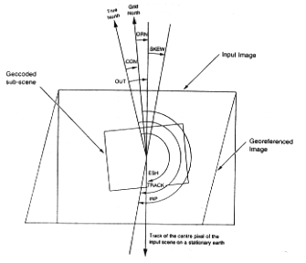
ORN Orientation of processed image from Grid North (= OUT-CON) CON Convergence of the meridians (angle between True North and Grid North) (fields 21, 27, 38, 46) SKEW Image skew due to Earth rotation (field 11) ESH Effective scene heading relative to a stationnary earth (field 51) TRACK Real scene center track (= ESH+SKEW) INP Orientation of input image from Grid North (= ESH+SKEW-CON) OUT Orientation of processed image from True North (field 74) (for geocoded images OUT = CON if orientation is to Map Vertical, and OUT = 0 if orientation is to True North) All angles are defined to be positive in the clockwise direction Map Projection Ancillary Record Contents
(NOTE: in the case of the Mu/Pan HIS merged products, this record reports information corresponding to the multispectral image, unless otherwise stated specifically - please refer to Figure B-5)
Field # Byte #(s) Data Type Description (Definition and Value) 1 1-4 B4 Record number = 3|10 2 5 B1 The first Subtype code= 044|8 3 6 B1 Record type code =044|8 4 7 B1 The second subtype code =022|8 5 8 B1 The third subtype code =011|8 6 9-12 B4 Record Length =4680|10 Fields #7~#11 are for data related to uncorrected scenes and are, threfor, effective only for processing levels 1A and 1B1. For processing level 1B2 these fields will contain blanks. 7 13-28 I16 Number of nominal pixels per line (5000/10000) 8 29-44 I16 Number of nominal lines per scene (5000/10000) 9 45-60 F16.7 Nominal inter-pixel destance (n) at the scene centre 10 61-76 F16.7 Nominal inter-line destance (m) at the scene centre 11 77-92 F16.7 Image skew (milliradian ) (refer to Figure B-5) Fields #12~#20 are valid for level 1B2 UTM projection products only. Otherwise, these fields will contain blanks. 12 93-96 I4 Hemisphere =
. bbb0 : Northern Hemisphere
. bbb1 : Southern Hemisphere13 97-108 I12 UTM zone number for uncorrected image The latitude and longitude of this GRS centre converted into UTM coordinates. 14 109-124 F16.7 Nominal GRS centre position (Northing -km) 15 125-140 F16.7 Nominal GRS centre position (Easting -km) The latitude and longitude of this scene centre converted into UTM coordinates. 16 141-156 F16.7 Scene centre position (Northing -km) 17 157-172 F16.7 Scene centre position (Easting -km) 18 173-188 F16.7 Vertical offset between the scene center and the nominal GRS center (km). The value is obtained by deducting the value of field #16 from that of field #14. 19 189-204 F16.7 Horizontal offset between the scene center and the nominal GRS center (km). The value is obtained by deducting the value of field #17 from that of field #15. 20 205-220 F16.7 Angle between the map projection vertical axis and the true north at scene centre (radians ) (refer to Figure B-5) Fields #21~#27 are valid for level 1B2 SOM projection products only. Otherwise, these fields will contain blanks. The latitude and longitude of the nominal RSP centre converted into SOM coordinates: 21 221-236 F16.7 X coordinates of the nominal RSP center (km) 22 237-252 F16.7 Y coordinates of the nominal RSP center (km) The latitude and longitude of the scene centre converted into SOM coordinates: 23 253-268 F16.7 X coordinates of the scene center (km) 24 269-284 F16.7 Y coordinates of the scene center (km) 25 285-300 F16.7 Vertical offset between the nominalRSP center and the scene center. The value is obtained by deducting the value of field #24 from #22. 26 301-316 F16.7 Horizonal offset between the nominalRSP center and the scene center. The value is obtained by deducting the value of field #23 from #21. 27 317-332 F16.7 Angle between the map projection vertical axis and the true north (radian). See field #20 for definition (refer to Figure B-5). Fields #28~#38 are valid for level 1B2 polarstereographic pfojection products only. Otherwise, these fields will contain blanks. 28 333-348 F16.7 Latitude of map projection origin (degree) 29 349-364 F16.7 Longitude of map projection origin (degree) 30 365-380 F16.7 Reference latitude (degree) 31 381-396 F16.7 Reference longitude (degree) The latitude and longitude of the nominal GRS centre converted into polarstereographic coordinates: 32 397-412 F16.7 X coordinates of the nominal GRS center (km) 33 413-428 F16.7 Y coordinates of the nominal GRS center (km) The latitude and longitude of the scene centre converted into polarstereographic coordinates: 34 429-444 F16.7 X coordinates of the scene center (km) 35 445-460 F16.7 Y coordinates of the scene center (km) 36 461-476 F16.7 Vertical offset between the nominal GRS center and the scene center. The value is obtained by deducting the value of field #35 from #33. 37 477-492 F16.7 Horizontal offset between the nominal GRS center and the scene center. The value is obtained by deducting the value of field #34 from #32. 38 493-508 F16.7 Angle between the map projection vertical axis and the true north (radian). See field #20 for definition (refer to Figure B-5). Fields #39~#46apply only to corrected scenes and are, therefore,effective only for processing level 1B2. Otherwise, these fields will contain blanks. 39 509-524 F16.7 Number of nominal pixels per line 40 525-540 F16.7 Number of nominal lines per line 41 541-556 F16.7 Nominal output inter-pixel distance 42 557-572 F16.7 Nominal output inter-linedistance 43 573-588 A16 Blank 44 589-604 A16 Blank 45 605-620 A16 Blank 46 621-636 F16.7 Angle between the map projection axis and the true north (radian). See field #20 for definition (refer to Figure B-5). 47 637-652 F16.7 Nominal satellite orbit inclination (degree) 48 653-668 F16.7 Longitude of nominal ascending node on the equator (radian) 49 669-684 F16.7 Nominal satellite altitude (km) 50 685-700 F16.7 Nominal ground speed (km/sec) 51 701-716 F16.7 Effective Scene heading angle at the scene center time measured from True North (radian) (refer to Figure B-5) 52 717-732 F16.7 = 'b~b0.0' 53 732-748 F16.7 Swath angle (nominal - degree= 5.7) 54 749-764 F16.7 Nominal scan rate (scans/sec = 1000/1.2 for Panchromatic and 1000/2.4 for Multispectral) 55 765-780 A16 Name of reference ellipoid 56 781-796 F16.7 Semimajor axis of reference ellipsoid (meters) 57 797-812 F16.7 Semiminor axis of reference ellipsoid (meters) 58 813-828 F16.7 Datum shift referenced to Greenwich :dx (meters) 59 829-844 F16.7 Datum shift referenced to Greenwich :dy (meters) 60 845-860 F16.7 Datum shift referenced to Greenwich :dz (meters) 61 861-876 F16.7 Datum rotational shift: 1(arc- second - 1/3600 degree) 62 877-892 F16.7 Datum rotational shift: 2(arc- second ) 63 893-908 F16.7 Datum rotational shift: 3(arc- second ) 64 909-924 F16.7 Scale factor of refernce ellipsoid 65 925-956 A32 32-character string to identify geodetic system used with map projections. Blank for AVNIR levels 1A and 1B1 Fields 66 through 73 store the (line, pixel), (latitude, longitude), (X,Y) transformation coefficients :
P = P0 + P1I + P2J + P3IJ + P4I2 + P5J2
L = L0 + L1I + L2J +L3IJ +L4I2 +L5J2
I = I0 + I1P + I2L + I3PL + I4P2 + I5L2
J = J0 + J1P + J2L + J3PL + J4P2 + J5L2
Y = Y0 + Y1P + Y2L + Y3PL + Y4P2 + Y5L2
X = X0 + X1P + X2L + X3PL + X4P2 + X5L2
I' = I'0 + I'1P + I'2L + I'3PL + I'4P2 + I'5L2
J' = J'0 + J'1P + J'2L + J'3PL + J'4P2 + J'5L2
where :
(I,J), (I',J') are line and pixel of corrected image
(P,L) are degrees of latitude and longitude
(Y,X) are distance in meters
(Y,X) and (I',J')are only valid for level 1B2 products.
Storage format =so.NNNNNNNNNNNNNNNND+/-NNN
(Note : these formulas are adapted from the SPOT CCT format)66 957-1100 6(G24.16E3) Stores six coefficients fromP0 toP5 67 1101-1244 6(G24.16E3) Stores six coefficients fromL0 toL5 68 1245-1388 6(G24.16E3) Stores six coefficients from I0 to I5 69 1389-1532 6(G24.16E3) Stores six coefficients from J0 to J5 70 1533-1676 6(G24.16E3) Stores six coefficients from Y0 to Y5 (only valid for level 1B2 products and set to blanks for 1A and 1B1 products) 71 1677-1820 6(G24.16E3) Stores six coefficients from X0 to X5 (only valid for level 1B2 products and set to blanks for 1A and 1B1 products) 72 1821-1964 6(G24.16E3) Stores six coefficients from I'0 to I'5 (only valid for level 1B2 products and set to blanks for 1A and 1B1 products) 73 1965-2108 6(G24.16E3) Stores six coefficients from J'0 to J'5 (only valid for level 1B2 products and set to blanks for 1A and 1B1 products) 74 2109-2132 G24, 16E3 Output coordinate rotation angle measured from True North for 1B2 products and set to zero for 1A 1B1 products =0.NNNNNNNNNNNNNNNND+/-NNN (Radians) 75 2133-4680 A2548 Blank Radiometric Ancillary Record Contents
(NOTE : in the case of the Mu/Pan HIS merged products, this record reports information corresponding to the multispectral image, unless otherwise stated specefically. Furthermore, where fields are available for all bands, in the case of the Mu/Pan HIS merged products, the multispectsal and navigation fields are extraced from the multispectral image, while the panchromatic fields are extracted from the panchromatic image)
Field # Byte #(s) Data Type Description (Definition and Value) 1 1-4 B4 Record number =4|10 2 5 B1 The first Subtype code=077|8 3 6 B1 Record type code =044|8 4 7 B1 The second subtype code =022|8 5 8 B1 The third subtype code =011|8 6 9-12 B4 Record Length =4680|10 7 13-16 A4 Sensor Operating Mode 8 17-20 I4 Lower limit of strength after correction ='bbb0' 9 21-24 I4 Upper limit of strength after correction ='b255' Exposure Coefficients (fields 10-15) :
The values in fields 10-15 provide the normalized exposure coefficient engineering units, which are normally expressed as real values between 0 and 1. The integer values in these fields may be converted to thecorresponding real values by multiplying by 10-4. See also the explanatory notes at the end of this table.10 25-29 I5 Exposure Coefficient- Multispectral Band 1 11 30-34 I5 Exposure Coefficient- Multispectral Band 2 12 35-39 I5 Exposure Coefficient- Multispectral Band 3 13 40-44 I5 Exposure Coefficient- Multispectral Band 4 14 45-49 I5 Exposure Coefficient- Pan Band 15 50-54 I5 Exposure Coefficient- Navigation Band 16 55 A1 Blank 17 56 A1 Blank 18 57-62 A6 Sensor Gains :
Multispectral products: 'XXXXbX' (4 multispectral bands plus navigation band);
Panchromatic products: 'bbbbXX' (panchromatic band plus navigation band);
HIS merged products: 'XXXXXX' (4 multispectral bands. panchromatic band plus navigation band) where X represents the sensor gain for each band, and can have the values:
L = Low Gain
N =Normal Gain
H = High Gain
S = Super Gain19 63 A1 Compression mode = 'A' A = '7' : 7-bit
'V' : variable length
'F' : fixes length20 64-66 A3 Blank 21 67-78 A12 The first time of telemetry (Hour : Minute : Second) = 'HH:MM:SS.SSS' (no zero suppression) 22 79-86 F8.3 AVNIR detector temp.1 (°C--Mu. band 1) 23 87-94 F8.3 AVNIR detector temp.2 (°C--Mu. band 2) 24 95-102 F8.3 AVNIR detector temp.3 (°C--Mu. band 3) 25 103-110 F8.3 AVNIR detector temp.4 (°C--Mu. band 4) 26 111-118 F8.3 AVNIR detector temp.5 (°C--Mu. band 5) 27 119-126 F8.3 AVNIR detector temp.6 (°C--Mu. band 6) 28 127-134 F8.3 Multispectral PreAmp/Driver circuit temp. 29 135-142 F8.3 Panchtomatic/Navigation PreAmp/Driver circuit temp. 30 143-150 F8.3 Process Amp temperatrure 31 151-2686 A2536 Blank 32 2687-2694 A8 Blank 33 2695-2702 A8 Blank Gain, Offset :
Gains and offset below are for conversion from calibrated digital numbers to radiance s: W/m2/sr/[micro]m34 2703-2718 2F8.4 Band 1 gain, offset 35 2719-2734 2F8.4 Band 2 gain, offset 36 2735-2750 2F8.4 Band 3 gain, offset 37 2751-2766 2F8.4 Band 4 gain, offset 38 2767-2782 2F8.4 Band P gain, offset 39 2783-2798 A16 Blank 40 2799-2814 A16 Blank 41 2815-2830 A16 Blank 42 2831-4680 A1850 Blank Clarifications - Radiometric Ancillary Record
The exposure coefficients in fields 10-15 are derived from the exposure settings received in the downlinked telemetry data based on Table 5 of the AVNIR Telemetry Definition document (document R-6).Ephemeris Ancillary Record Contents
(NOTE: in the case of the Mu/Pan HIS merged products, this record reports information corresponding to the multispectral image, unless otherwise stated specifically)
Field # Byte #(s) Data Type Description (Definition and Value) 1 1-4 B4 Record number =5|10 2 5 B1 The first Subtype code=366|8 3 6 B1 Record type code =044|8 4 7 B1 The second subtype code =022|8 5 8 B1 The third subtype code =011|8 6 9-12 B4 Record Length =4680|10 7 13-20 A8 Blank 8 21-24 A4 Blank (Fields #9~#15 are the first orbit data set, unused orbit data set have the time field set to blanks) 9 25-40 A16 Time (UT) of orbit data ='YYMMDDHHNNSSXXXb'
YY : Year (last two digits of A.D. year) ('00'~ '99')
MM : Month ('01'~ '12')
DD : Day ('01'~ '31')
HH : Hour ('00'~ '23')
NN : Minute ('00'~ '59')
SS : Second ('00'~ '59')
XXX : Millsecond ('000'~ '999')10 41-52 F12.5 X component of satellite position in fixed coordinate system of the earth (km) (ECR) 11 53-64 F12.5 Y component of satellite position in fixed coordinate system of the earth (km) (ECR) 12 65-76 F12.5 Z component of satellite position in fixed coordinate system of the earth (km) (ECR) 13 77-88 F12.8 X component of satellite speed in fixed coordinate system of the earth not including earth rotation velocity (km/sec) (X') (ECR) 14 89-100 F12.8 Y component of satellite speed in fixed coordinate system of the earth not including earth rotation velocity (km/sec) (Y') (ECR) 15 101-112 F12.8 Z component of satellite speed in fixed coordinate system of the earth not including earth rotation velocity (km/sec) (Z') (ECR) 16 113-200 See above The second orbit data sets (repeat of fields above 9 to 15). 17 201-2488 See above The 3rd orbit data sets (repeat of fields above 9 to 15). 18 2489-3544 See above The 29th to 40th orbit data sets (these are only required when the "customer geocodeable" productois requested) (repeat of above fields 9 to 15 above) Fields #19~#22 are the first attitude data set 19 3545-3560 A16 Time (UT) of attitude data = 'YYMMDDHHNNSSXXXb' (See field #9 for description) 20 3561-3568 F8.5 Roll (degrees) 21 3569-3576 F8.5 Pitch (degrees) 22 3577-3584 F8.5 Yaw (degrees) 23 3585-4104 See above The 2nd to 14th attitude data sets (repeat of above fields 19 to 22). 24 4105-4344 See above The 15th to 20th attitude data sets (these above are only required when the "customer geocodeable" product is requested) (repeat of above fields 19 to 22). Fields 25-32 are extracted from the Facility Related Data Record in the level 0 logical volume (refer to Document R-5) 25 4345-4365 A21 Observation start date/time = 'YYYYMMDDbhh:mm:ss.ttt' 26 4366-4386 A21 Observation completion date/time = 'YYYYMMDDbhh:mm:ss.ttt' 27 4387-4391 I5 Time deviation information 1: Cumulative orbit number computed with time deviation 28 4392-4412 A21 Time deviation information 1: Valid data period (start) = 'YYYYMMDDbhh:mm:ss.ttt' (UTC) 29 4413-4433 A21 Time deviation information 1: Valid data period (completion) = 'YYYYMMDDbhh:mm:ss.ttt' (UTC) 30 4434-4446 F13.10 Time deviation information 1: Satellite counter cycles = 'SX.XXXXXXXXXX' (second) 31 4447-4457 A11 Time deviation information 1: Reference satellite time counter = 'NNNNNNNNNNN' 32 4458-4478 A21 Time deviation information 1: Reference satellite time = 'YYYYMMDDbhh:mm:ss.ttt' (UTC) Fields 33-45 are extracted from the Platform Position Record, in the level 0 logical volume, colses to scene centre time (refer to Document R-5) 33 4479-4482 A4 Orbit precesion = 'XXXX'
'OPRD' :Predicted value
'PPED' : Determinid value34 4483-4485 I3 IERS report information :UTC-TAO seconds = 'sss' 35 4486-4494 F9.5 IERS report information :UTIR-TAO seconds = 'sss.ttttt' 36 4495-4502 F8.4 IERS report information :Polar motion parameter Xpm degree-second 37 4503-4510 F8.4 IERS report information :Polar motion parameter Ypm degree-second 38 4511-4531 A21 Orbit date/time (UT) = 'YYYYMMDDbhh:mm:ss.000' 39 4532-4563 A32 Orbit element coordinates = 'ECIbbbbbbbbbbbbbbbbbbbbbbbbbbbbb' 40 4564-4577 F14.6 Satellite position component x (Km) 41 4578-4591 F14.6 Satellite position component y (Km) 42 4592-4605 F14.6 Satellite position component z (Km) 43 4606-4619 F14.6 Satellite velocity component x' (Km/s) 44 4620-4633 F14.6 Satellite velocity component y' (Km/s) 45 4634-4647 F14.6 Satellite velocity component z' (Km/s) 46 4648-4680 A33 Blank Telemetry Ancillary Record Contents
Field # Byte #(s) Data Type Description (Definition and Value) 1 1-4 B4 Record number =6|10 ~7|10 2 5 B1 The first Subtype code=055|8 3 6 B1 Record type code =044|8 4 7 B1 The second subtype code =022|8 5 8 B1 The third subtype code =011|8 6 9-12 B4 Record Length =4680|10 7 13-20 A8 First major frame start time (GMT) = 'HHMMSSXX'
HH :Hour ('00'~ '23')
MM :Minute ('00'~ '59')
SS :Second ('00'~ '59')
XX :milliseconds ('10's) ('00'~ '99')8 21-980 3B320 Three major frames of AVNIR HK and PCD data. 9 981-4680 A3700 Blank Clarification - Telemetry Ancillary Record
The telemetry data reported in this record will be extracted from near the scene center. In the case of Multispectral or Pandhromatic products, only a single telemetry record will be made available. In the case of Mu/Pan HIS Merged products, two telemetry records will be reported, the first from the multispectral image and the second form the panchromatic image.Image File Descriptor Record Contents
Field # Byte #(s) Data Type Description (Definition and Value) 1 1-180 Common file descriptor. 2 181-186 I6 Number of image records = N (for BSQ) or N*B (for BIL)
N :Number of lines per band
B :Number of bands3 187-192 I6 Image record length (<22300 bytes) 4 193-216 A24 Blank 5 217-220 I4 Number of bits per pixel = 'bbb7' or 'bbb8' 6 221-224 I4 Number of pixels per data = 'bbb1' 7 225-228 I4 Number of bytes per data = 'bbb1' 8 229-232 A4 Bit list of pixel
'RJLR' for right justified
'LJLR' for left justified9 233-236 I4 Number of bands per file
= 'bbb1' : for BSQ
='bbbN' : for BI
(N : number of bands)10 237-244 I8 Number of lines per band (<22000) 11 245-248 I4 Number of left border pixels per line = 'bbb0' 12 249-256 I8 Number of image pixels per line (<22000) 13 257-260 I4 Number of right border pixels per line = 'bbb0' ~ 'bbb7' 14 261-264 I4 Number of top border lines = 'bbb0' 15 265-268 I4 Number of bottom border lines = 'bbb0' 16 269-272 A4 Image format ID
= 'BSQb' : for BSQ
= 'BILb' : for BIL17 273-276 I4 Number of records per line (single band) = 'bbb1' 18 277-280 I4 Number of records per line
='bbb1' : for BIQ
= 'bbbN' : for BIL (N = number of bands)19 281-284 I4 Number of bytes of record header which covers both record identifier (12) and prefix data (20) data per record = 'bb32' 20 285-292 I8 Number of image data bytes per record including dummy pixels (<22000) 21 293-296 I4 Number of bytes of suffix data per record = 'b268' 22 297-300 A4 Prefix data repeat flag ='bbbb' 23 301-208 A8 Scan line number locator a ='bbb1b4PB' 24 309-316 A8 Band number locator a ='bbb5b4PB' 25 317-324 A8 Scan start time locator a ='bbb9b4PB' 26 325-332 A8 Left dummy pixel locator a ='bb13b4PB' 27 333-340 A8 Right dummy pixel locator a ='bb17b4PB' 28 341-372 A32 Blank 29 373-380 A8 Blank 30 381-388 A8 Blank 31 389-396 A8 Blank 32 397-432 A36 Data format type ID = 'INTEGER*1b~b' 33 433-436 A4 Data format type ID code ='I*1b' 34 437-440 I4 Number of left unused bits in pixel data ='bbb0' 35 441-444 I4 Number of right unused bits in pixel data ='bbb0' for 8bit and 'bbb1' for 7bit 36 445-448 I4 The maximum value of pixel data = 'b255' for 8bit and 'b254' for 7bit 37 449-452 A4 Blank 38 453-460 A8 Blank 39 461-468 A8 Blank 40 469-Same number of bytes as in Image Record A Blank TRAIL Image Data Record Contents
Field # Byte #(s) Data Type Description (Definition and Value) 1 1-4 B4 Record number =2|10 ~(n+1)|10 (where, n = number of image data records) when the image file descriptor is '1'. 2 5 B1 The first Subtype code=355|8 3 6 B1 Record type code =355|8 4 7 B1 The second subtype code =222|8 5 8 B1 The third subtype code =022|8 6 9-12 B4 Record Length Prefix Data : 7 13-16 B4 Line number (to be counted from the first line of the full scene regarded as 1) 8 17-20 B4 Band number 9 21-24 B4 Scan time (millisecond).
・Total milliseconds in a day (effective only befor correction, and 0 after correcrtion, i.e., 1B2 products)10 25-28 B4 Number of left dummy pixels 11 29-32 B4 Number of right dummy pixels 12 33 - (NPIX +32) Image Data Suffix Data :(Note that SF1= (NPIX +33)) Dark Current data (fields #13-16) is included in level 1A products only. For all other product types, 000|8
13 SF1 B1 First Dark Current data reading ('A') 14 (SF1+1) B1 Second Dark Current data reading ('B') 15 (SF1+2) B1 Third Dark Current data reading for panchromatic imagery only ('C') 16 (SF1+3) B1 Forth Dark Current data reading for panchromatic imagery only ('D') Navigation Data :
(Note: Navigation Image data shall be contained in AVNIR levels 1A and 1B1 products. The Navigation Image data shall be raw imagery (uncorrected) and included in both pachromatic and multispectral bands, and shall be duplicated for every band of multispectral bands for BSQ and BIL formats). For all other product types,000|817 (SF1+4) - (SF1+131) 1(B64) First set of navigation data 18 (SF1+132) B1 First Navigation Dark Current data reading ('A1') 19 (SF1+133) B1 Second Navigation Dark Current data reading ('B1') 20 (SF1+134) B1 Third Navigation Dark Current data reading ('C1') 21 (SF1+135) B1 Forth Navigation Dark Current data reading ('D1') 22 (SF1+136) - (SF1+263) 2(B64) Second set of navigationdata (Multispectral band imagery only) 23 (SF1+264) B1 First Navigation Dark Current data reading ('A2') 24 (SF1+265) B1 Second Navigation Dark Current data reading ('B2') 25 (SF1+266) B1 Third Navigation Dark Current data reading ('C2') 26 (SF1+267) B1 Forth Navigation Dark Current data reading ('D2') Trailer File Descriptor Record Contents
Field # Byte #(s) Data Type Description (Definition and Value) 1 1-180 Common file descriptor (See Table B-7). 2 181-186 I6 Number of image records
='bbbbb1' for BSQ
='bbbbbN' for BIL (N = number of bands)3 187-192 I6 Record length ='bb4680' 4 193-216 A24 Blank 5 217-232 A16 Blank 6 233-4680 A4448 Blank Trailer Record Contents
Field # Byte #(s) Data Type Description (Definition and Value) 1 1-4 B4 Record number =2|10=2|10~ 6|10 for BIL 2 5 B1 The first Subtype code=022|8 3 6 B1 Record type code =366|8 4 7 B1 The second subtype code =022|8 5 8 B1 The third subtype code =011|8 6 9-12 B4 Record Length =4680|10 7 13-16 I4 Trailer record number
='bbb1' : for BSQ
='bbb1'~ 'bbb5' : for BIL8 17-20 I4 Trailer record number ='bbb1' 9 21-2048 A2028 Blank 10 2049-3072 256B4 Histogram (Total quantity of respective pixels is 0~255) 11 3073-4680 A1608 Blank
[TOC] [INTRO] [DOCS] [OVERVIEW]
[ADEOS HOME]

Earth Observation Research Center
Last Update: 02 July 1998Comments to: